Jacaraú geodata
Jacaraú (Paraíba) is a populated place; located in Brazil in America/Fortaleza (GMT-3) time zone. With population of 7,035 people, there are 1829 cities with bigger population in this country. Compared to other cities in Brazil, 82.4% of cities are located further ↓South; 97.3% of cities are located further ←West and 64.3% of cities have higher elevation than Jacaraú. Note1


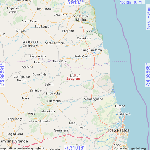
Jacaraú GPS coordinates[2]
6° 36' 43.992" South, 35° 17' 34.008" West
| Map corner | latitude | longitude |
|---|---|---|
| Upper-left | -5.9133°, | -35.99591° |
| Center: | -6.61222°, | -35.29278° |
| Lower-right: | -7.31016°, | -34.58966° |
| Map W x H: | 155.3×155.3 km | = 96.5×96.5mi |
| max Lat: | 2.81972° ⇑17.6% North |
| Jacaraú: | -6.61222° |
| min Lat: | ⇓82.4% South -33.69111° |
| min Long | Jacaraú | max Long |
| -72.89583° | -35.29278° | -32.41083° |
| W 97.3%⇐ | ⇒2.7% E |
Elevation
Elevation of Jacaraú is 173 m = 568 ft, and this is 207.9 m = 682 ft below average elevation for this country.
| Max E: |
1603 m = 5259 ft | 64.3% |
| Avg. | 380.9 m = 1250 ft | |
| Jacaraú | 173 m = 568 ft | |
Min E: |
0 m = 0 ft | 35.7% |
See also: Brazil elevation on elevation.city.
Geographical zone
Jacaraú is located in South Torrid zone (between Equator and Tropic of Capricorn). Distance of Equator is 735.2 km =456.8 mi to North.| Distance of | km | miles | from Jacaraú |
|---|---|---|---|
| Equator | 735.2 | 456.8 | to North |
| Tropic Capricorn | 1870.7 | 1162.4 | to South |
| Antarctic Circle | 6666 | 4142.1 | to South |
| South Pole | 9271.9 | 5761.3 | to South |


Nearby cities:
15 places around Jacaraú: (largest is in red/bold)
• Alagoinha
46.8 km =29.1 mi,  216°
216°
• Bananeiras
40.6 km =25.2 mi,  247°
247°
• Belém
28 km =17.4 mi, 251°
• Canguaretama
31.5 km =19.6 mi,  35°
35°
• Dona Inês
36.9 km =22.9 mi,  269°
269°
• Goianinha
39.6 km =24.6 mi,  12°
12°
• Guarabira
34.7 km =21.6 mi, 218°
• Mamanguape
31.2 km =19.4 mi,  143°
143°
• Montanhas
14.1 km =8.8 mi,  2°
2°
• Nova Cruz
21.6 km =13.4 mi,  313°
313°
• Pedro Velho
20.8 km =12.9 mi,  22°
22°
• Pirpirituba
29.4 km =18.3 mi,  230°
230°
• Rio Tinto
31.6 km =19.6 mi,  132°
132°
• Santo Antônio
39.3 km =24.4 mi,  328°
328°
• Solânea
31.6 km =19.6 mi,  239°
239°
Sources, notices
• [Note1] Compared only with cities in Brazil existing in our database
• [Src1] Map data: © OpenStreetMap contributors (CC-BY-SA)
• [Src2] Other city data from geonames.org with taken over terms of usage.
• [Src3] Geographical zone / Annual Mean Temperature by Robert A. Rohde @ Wikipedia
