Canguaretama geodata
Canguaretama (Rio Grande do Norte) is a populated place; located in Brazil in America/Fortaleza (GMT-3) time zone. With population of 18,873 people, there are 987 cities with bigger population in this country. Compared to other cities in Brazil, 83.6% of cities are located further ↓South; 98.4% of cities are located further ←West and 98.3% of cities have higher elevation than Canguaretama. Note1


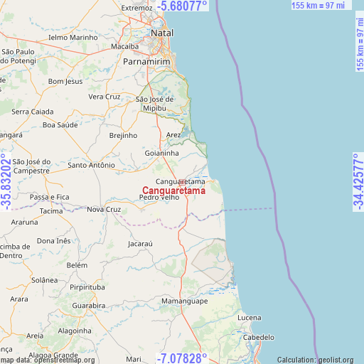
Canguaretama GPS coordinates[2]
6° 22' 48" South, 35° 7' 44.004" West
| Map corner | latitude | longitude |
|---|---|---|
| Upper-left | -5.68077°, | -35.83202° |
| Center: | -6.38°, | -35.12889° |
| Lower-right: | -7.07828°, | -34.42577° |
| Map W x H: | 155.4×155.4 km | = 96.6×96.6mi |
| max Lat: | 2.81972° ⇑16.4% North |
| Canguaretama: | -6.38° |
| min Lat: | ⇓83.6% South -33.69111° |
| min Long | Canguaretama | max Long |
| -72.89583° | -35.12889° | -32.41083° |
| W 98.4%⇐ | ⇒1.6% E |
Elevation
Elevation of Canguaretama is 6 m = 20 ft, and this is 374.9 m = 1230 ft below average elevation for this country.
| Max E: |
1603 m = 5259 ft | 98.3% |
| Avg. | 380.9 m = 1250 ft | |
| Canguaretama | 6 m = 20 ft | |
Min E: |
0 m = 0 ft | 1.7% |
See also: Brazil elevation on elevation.city.
Geographical zone
Canguaretama is located in South Torrid zone (between Equator and Tropic of Capricorn). Distance of Equator is 709.4 km =440.8 mi to North.| Distance of | km | miles | from Canguaretama |
|---|---|---|---|
| Equator | 709.4 | 440.8 | to North |
| Tropic Capricorn | 1896.5 | 1178.4 | to South |
| Antarctic Circle | 6691.8 | 4158.1 | to South |
| South Pole | 9297.7 | 5777.3 | to South |


Nearby cities:
15 places around Canguaretama: (largest is in red/bold)
• Arês
20.9 km =13 mi,  350°
350°
• Belém
56.5 km =35.1 mi,  232°
232°
• Brejinho
32.8 km =20.4 mi,  309°
309°
• Goianinha
15.8 km =9.8 mi,  324°
324°
• Jacaraú
31.5 km =19.6 mi,  215°
215°
• Mamanguape
51 km =31.7 mi,  179°
179°
• Montanhas
21.1 km =13.1 mi,  236°
236°
• Nova Cruz
35.4 km =22 mi,  252°
252°
• Nísia Floresta
33.3 km =20.7 mi,  344°
344°
• Parnamirim
53.7 km =33.4 mi, 344°
• Pedro Velho
12.2 km =7.6 mi, 237°
• Pirpirituba
60.4 km =37.5 mi, 222°
• Rio Tinto
47.3 km =29.4 mi,  173°
173°
• Santo Antônio
39.4 km =24.5 mi,  281°
281°
• São José de Mipibu
36 km =22.4 mi, 340°
Sources, notices
• [Note1] Compared only with cities in Brazil existing in our database
• [Src1] Map data: © OpenStreetMap contributors (CC-BY-SA)
• [Src2] Other city data from geonames.org with taken over terms of usage.
• [Src3] Geographical zone / Annual Mean Temperature by Robert A. Rohde @ Wikipedia
