Mamanguape geodata
Mamanguape (Paraíba) is a populated place; located in Brazil in America/Fortaleza (GMT-3) time zone. With population of 27,606 people, there are 715 cities with bigger population in this country. Compared to other cities in Brazil, 81.3% of cities are located further ↓South; 98.4% of cities are located further ←West and 81.8% of cities have higher elevation than Mamanguape. Note1


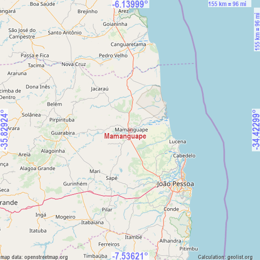
Mamanguape GPS coordinates[2]
6° 50' 18.996" South, 35° 7' 33.996" West
| Map corner | latitude | longitude |
|---|---|---|
| Upper-left | -6.13999°, | -35.82924° |
| Center: | -6.83861°, | -35.12611° |
| Lower-right: | -7.53621°, | -34.42299° |
| Map W x H: | 155.2×155.2 km | = 96.4×96.4mi |
| max Lat: | 2.81972° ⇑18.7% North |
| Mamanguape: | -6.83861° |
| min Lat: | ⇓81.3% South -33.69111° |
| min Long | Mamanguape | max Long |
| -72.89583° | -35.12611° | -32.41083° |
| W 98.4%⇐ | ⇒1.6% E |
Elevation
Elevation of Mamanguape is 39 m = 128 ft, and this is 341.9 m = 1122 ft below average elevation for this country.
| Max E: |
1603 m = 5259 ft | 81.8% |
| Avg. | 380.9 m = 1250 ft | |
| Mamanguape | 39 m = 128 ft | |
Min E: |
0 m = 0 ft | 18.2% |
See also: Brazil elevation on elevation.city.
Geographical zone
Mamanguape is located in South Torrid zone (between Equator and Tropic of Capricorn). Distance of Equator is 760.4 km =472.5 mi to North.| Distance of | km | miles | from Mamanguape |
|---|---|---|---|
| Equator | 760.4 | 472.5 | to North |
| Tropic Capricorn | 1845.5 | 1146.7 | to South |
| Antarctic Circle | 6640.8 | 4126.4 | to South |
| South Pole | 9246.7 | 5745.6 | to South |


Nearby cities:
15 places around Mamanguape: (largest is in red/bold)
• Bayeux
38.4 km =23.9 mi,  146°
146°
• Cabedelo
35.9 km =22.3 mi,  116°
116°
• Cruz do Espírito Santo
33.8 km =21 mi,  172°
172°
• Guarabira
40.2 km =25 mi,  267°
267°
• Gurinhém
45.7 km =28.4 mi,  226°
226°
• Jacaraú
31.2 km =19.4 mi,  323°
323°
• João Pessoa
42.3 km =26.3 mi,  136°
136°
• Mari
32.6 km =20.3 mi,  220°
220°
• Montanhas
43.1 km =26.8 mi,  335°
335°
• Mulungu
42.4 km =26.3 mi,  240°
240°
• Pedro Velho
45.6 km =28.3 mi,  346°
346°
• Pirpirituba
41.6 km =25.8 mi,  279°
279°
• Rio Tinto
6.4 km =4 mi,  51°
51°
• Santa Rita
34.7 km =21.6 mi, 151°
• Solânea
46.6 km =29 mi, 281°
Sources, notices
• [Note1] Compared only with cities in Brazil existing in our database
• [Src1] Map data: © OpenStreetMap contributors (CC-BY-SA)
• [Src2] Other city data from geonames.org with taken over terms of usage.
• [Src3] Geographical zone / Annual Mean Temperature by Robert A. Rohde @ Wikipedia
