Afogados da Ingazeira geodata
Afogados da Ingazeira (Pernambuco) is a populated place; located in Brazil in America/Recife (GMT-3) time zone. With population of 25,060 people, there are 781 cities with bigger population in this country. Compared to other cities in Brazil, 76.2% of cities are located further ↓South; 86.1% of cities are located further ←West and 63.9% of cities have lower elevation than Afogados da Ingazeira. Note1


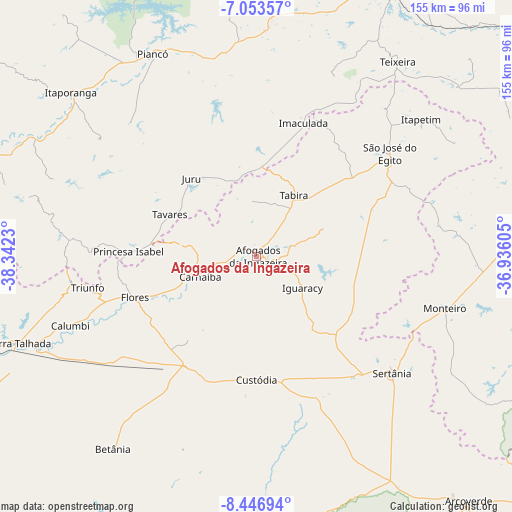
Afogados da Ingazeira GPS coordinates[2]
7° 45' 2.988" South, 37° 38' 21.012" West
| Map corner | latitude | longitude |
|---|---|---|
| Upper-left | -7.05357°, | -38.3423° |
| Center: | -7.75083°, | -37.63917° |
| Lower-right: | -8.44694°, | -36.93605° |
| Map W x H: | 154.9×154.9 km | = 96.3×96.3mi |
| max Lat: | 2.81972° ⇑23.8% North |
| Afogados da Ingazeira: | -7.75083° |
| min Lat: | ⇓76.2% South -33.69111° |
| min Long | Afogados da Ing | max Long |
| -72.89583° | -37.63917° | -32.41083° |
| W 86.1%⇐ | ⇒13.9% E |
Elevation
Elevation of Afogados da Ingazeira is 516 m = 1693 ft, and this is 135.1 m = 443 ft above average elevation for this country.
| Max E: |
1603 m = 5259 ft | 36.1% |
| Afogados da Ingazeira | 516 m 1693 ft | |
| Avg. | 380.9 m = 1250 ft | |
Min E: |
0 m = 0 ft | 63.9% |
See also: Brazil elevation on elevation.city.
Geographical zone
Afogados da Ingazeira is located in South Torrid zone (between Equator and Tropic of Capricorn). Distance of Equator is 861.8 km =535.5 mi to North.| Distance of | km | miles | from Afogados da Ingazeira |
|---|---|---|---|
| Equator | 861.8 | 535.5 | to North |
| Tropic Capricorn | 1744.1 | 1083.7 | to South |
| Antarctic Circle | 6539.4 | 4063.4 | to South |
| South Pole | 9145.3 | 5682.6 | to South |


Nearby cities:
15 places around Afogados da Ingazeira: (largest is in red/bold)
• Custódia
37.4 km =23.2 mi,  180°
180°
• Flores
39.2 km =24.4 mi,  250°
250°
• Imaculada
42.6 km =26.5 mi,  19°
19°
• Itaporanga
75.1 km =46.7 mi,  311°
311°
• Juru
30.9 km =19.2 mi,  320°
320°
• Manaíra
57 km =35.4 mi,  275°
275°
• Monteiro
59.2 km =36.8 mi,  105°
105°
• Piancó
69.3 km =43.1 mi,  332°
332°
• Princesa Isabel
39.1 km =24.3 mi,  272°
272°
• Serra Talhada
77.4 km =48.1 mi, 249°
• Sertânia
54.7 km =34 mi,  131°
131°
• São José do Egito
50.3 km =31.3 mi,  53°
53°
• Tabira
20.9 km =13 mi,  31°
31°
• Tavares
29.3 km =18.2 mi,  295°
295°
• Teixeira
72.4 km =45 mi,  35°
35°
Sources, notices
• [Note1] Compared only with cities in Brazil existing in our database
• [Src1] Map data: © OpenStreetMap contributors (CC-BY-SA)
• [Src2] Other city data from geonames.org with taken over terms of usage.
• [Src3] Geographical zone / Annual Mean Temperature by Robert A. Rohde @ Wikipedia
