Princesa Isabel geodata
Princesa Isabel (Paraíba) is a populated place; located in Brazil in America/Fortaleza (GMT-3) time zone. With population of 12,616 people, there are 1408 cities with bigger population in this country. Compared to other cities in Brazil, 76.4% of cities are located further ↓South; 84.4% of cities are located further ←West and 79.8% of cities have lower elevation than Princesa Isabel. Note1


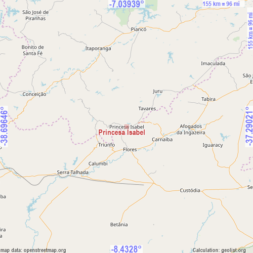
Princesa Isabel GPS coordinates[2]
7° 44' 12.012" South, 37° 59' 35.988" West
| Map corner | latitude | longitude |
|---|---|---|
| Upper-left | -7.03939°, | -38.69646° |
| Center: | -7.73667°, | -37.99333° |
| Lower-right: | -8.4328°, | -37.29021° |
| Map W x H: | 154.9×154.9 km | = 96.3×96.3mi |
| max Lat: | 2.81972° ⇑23.6% North |
| Princesa Isabel: | -7.73667° |
| min Lat: | ⇓76.4% South -33.69111° |
| min Long | Princesa Isabel | max Long |
| -72.89583° | -37.99333° | -32.41083° |
| W 84.4%⇐ | ⇒15.6% E |
Elevation
Elevation of Princesa Isabel is 686 m = 2251 ft, and this is 305.1 m = 1001 ft above average elevation for this country.
| Max E: |
1603 m = 5259 ft | 20.2% |
| Princesa Isabel | 686 m 2251 ft | |
| Avg. | 380.9 m = 1250 ft | |
Min E: |
0 m = 0 ft | 79.8% |
See also: Brazil elevation on elevation.city.
Geographical zone
Princesa Isabel is located in South Torrid zone (between Equator and Tropic of Capricorn). Distance of Equator is 860.2 km =534.5 mi to North.| Distance of | km | miles | from Princesa Isabel |
|---|---|---|---|
| Equator | 860.2 | 534.5 | to North |
| Tropic Capricorn | 1745.7 | 1084.7 | to South |
| Antarctic Circle | 6540.9 | 4064.3 | to South |
| South Pole | 9146.8 | 5683.6 | to South |


Nearby cities:
15 places around Princesa Isabel: (largest is in red/bold)
• Afogados da Ingazeira
39.1 km =24.3 mi,  92°
92°
• Coremas
80.5 km =50 mi,  3°
3°
• Custódia
54.9 km =34.1 mi,  135°
135°
• Flores
14.8 km =9.2 mi,  172°
172°
• Imaculada
65.8 km =40.9 mi,  54°
54°
• Itaporanga
51.1 km =31.8 mi,  340°
340°
• Juru
29.4 km =18.3 mi,  40°
40°
• Manaíra
18.1 km =11.2 mi,  280°
280°
• Piancó
60.3 km =37.5 mi,  6°
6°
• Serra Talhada
44 km =27.3 mi,  229°
229°
• São José de Piranhas
88.5 km =55 mi,  320°
320°
• São José do Belmonte
85.6 km =53.2 mi,  260°
260°
• São José do Egito
84.3 km =52.4 mi,  70°
70°
• Tabira
52.6 km =32.7 mi, 72°
• Tavares
16.9 km =10.5 mi, 48°
Sources, notices
• [Note1] Compared only with cities in Brazil existing in our database
• [Src1] Map data: © OpenStreetMap contributors (CC-BY-SA)
• [Src2] Other city data from geonames.org with taken over terms of usage.
• [Src3] Geographical zone / Annual Mean Temperature by Robert A. Rohde @ Wikipedia
