Flores geodata
Flores (Pernambuco) is a populated place; located in Brazil in America/Recife (GMT-3) time zone. With population of 11,692 people, there are 1507 cities with bigger population in this country. Compared to other cities in Brazil, 75.7% of cities are located further ↓South; 84.5% of cities are located further ←West and 59.4% of cities have lower elevation than Flores. Note1


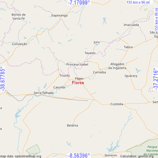
Flores GPS coordinates[2]
7° 52' 5.016" South, 37° 58' 28.992" West
| Map corner | latitude | longitude |
|---|---|---|
| Upper-left | -7.17099°, | -38.67785° |
| Center: | -7.86806°, | -37.97472° |
| Lower-right: | -8.56396°, | -37.2716° |
| Map W x H: | 154.9×154.9 km | = 96.3×96.3mi |
| max Lat: | 2.81972° ⇑24.3% North |
| Flores: | -7.86806° |
| min Lat: | ⇓75.7% South -33.69111° |
| min Long | Flores | max Long |
| -72.89583° | -37.97472° | -32.41083° |
| W 84.5%⇐ | ⇒15.5% E |
Elevation
Elevation of Flores is 467 m = 1532 ft, and this is 86.1 m = 282 ft above average elevation for this country.
| Max E: |
1603 m = 5259 ft | 40.6% |
| Flores | 467 m 1532 ft | |
| Avg. | 380.9 m = 1250 ft | |
Min E: |
0 m = 0 ft | 59.4% |
See also: Brazil elevation on elevation.city.
Geographical zone
Flores is located in South Torrid zone (between Equator and Tropic of Capricorn). Distance of Equator is 874.8 km =543.6 mi to North.| Distance of | km | miles | from Flores |
|---|---|---|---|
| Equator | 874.8 | 543.6 | to North |
| Tropic Capricorn | 1731.1 | 1075.7 | to South |
| Antarctic Circle | 6526.3 | 4055.3 | to South |
| South Pole | 9132.2 | 5674.5 | to South |


Nearby cities:
15 places around Flores: (largest is in red/bold)
• Afogados da Ingazeira
39.2 km =24.4 mi,  70°
70°
• Custódia
43.9 km =27.3 mi,  123°
123°
• Ibimirim
81.1 km =50.4 mi,  157°
157°
• Imaculada
73.9 km =45.9 mi,  43°
43°
• Itaporanga
65.6 km =40.8 mi,  342°
342°
• Juru
40.6 km =25.2 mi,  25°
25°
• Manaíra
26.8 km =16.7 mi,  312°
312°
• Piancó
74.7 km =46.4 mi,  3°
3°
• Princesa Isabel
14.8 km =9.2 mi,  352°
352°
• Serra Talhada
38.2 km =23.7 mi,  248°
248°
• Sertânia
81.5 km =50.6 mi,  106°
106°
• São José do Belmonte
86.5 km =53.7 mi,  270°
270°
• São José do Egito
88.5 km =55 mi,  60°
60°
• Tabira
57 km =35.4 mi, 57°
• Tavares
27.9 km =17.3 mi,  22°
22°
Sources, notices
• [Note1] Compared only with cities in Brazil existing in our database
• [Src1] Map data: © OpenStreetMap contributors (CC-BY-SA)
• [Src2] Other city data from geonames.org with taken over terms of usage.
• [Src3] Geographical zone / Annual Mean Temperature by Robert A. Rohde @ Wikipedia
