Canindé geodata
Canindé (Ceará) is a populated place; located in Brazil in America/Fortaleza (GMT-3) time zone. With population of 42,720 people, there are 495 cities with bigger population in this country. Compared to other cities in Brazil, 89.9% of cities are located further ↓South; 78.2% of cities are located further ←West and 66.6% of cities have higher elevation than Canindé. Note1


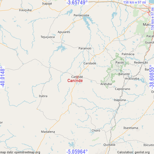
Canindé GPS coordinates[2]
4° 21' 32.004" South, 39° 18' 42.012" West
| Map corner | latitude | longitude |
|---|---|---|
| Upper-left | -3.65749°, | -40.0148° |
| Center: | -4.35889°, | -39.31167° |
| Lower-right: | -5.05964°, | -38.60855° |
| Map W x H: | 155.9×155.9 km | = 96.9×96.9mi |
| max Lat: | 2.81972° ⇑10.1% North |
| Canindé: | -4.35889° |
| min Lat: | ⇓89.9% South -33.69111° |
| min Long | Canindé | max Long |
| -72.89583° | -39.31167° | -32.41083° |
| W 78.2%⇐ | ⇒21.8% E |
Elevation
Elevation of Canindé is 154 m = 505 ft, and this is 226.9 m = 744 ft below average elevation for this country.
| Max E: |
1603 m = 5259 ft | 66.6% |
| Avg. | 380.9 m = 1250 ft | |
| Canindé | 154 m = 505 ft | |
Min E: |
0 m = 0 ft | 33.4% |
See also: Canindé elevation on elevation.city.
Geographical zone
Canindé is located in South Torrid zone (between Equator and Tropic of Capricorn). Distance of Equator is 484.7 km =301.2 mi to North.| Distance of | km | miles | from Canindé |
|---|---|---|---|
| Equator | 484.7 | 301.2 | to North |
| Tropic Capricorn | 2121.3 | 1318.1 | to South |
| Antarctic Circle | 6916.5 | 4297.7 | to South |
| South Pole | 9522.4 | 5916.9 | to South |


Nearby cities:
15 places around Canindé: (largest is in red/bold)
• Aracoiaba
55.2 km =34.3 mi,  91°
91°
• Baturité
47.5 km =29.5 mi, 85°
• Chorozinho
90.5 km =56.2 mi, 85°
• Guaiúba
82.8 km =51.4 mi,  64°
64°
• Irauçuba
85.9 km =53.4 mi,  322°
322°
• Itapagé
80.7 km =50.1 mi,  337°
337°
• Maracanaú
93.1 km =57.8 mi,  54°
54°
• Ocara
80.6 km =50.1 mi,  100°
100°
• Pacatuba
87.3 km =54.2 mi, 61°
• Pentecoste
63.1 km =39.2 mi,  4°
4°
• Quixadá
75.6 km =47 mi,  154°
154°
• Redenção
66.1 km =41.1 mi,  77°
77°
• São Gonçalo do Amarante
91.8 km =57 mi,  24°
24°
• Umirim
75.9 km =47.2 mi,  356°
356°
• Uruburetama
84.5 km =52.5 mi,  345°
345°
Sources, notices
• [Note1] Compared only with cities in Brazil existing in our database
• [Src1] Map data: © OpenStreetMap contributors (CC-BY-SA)
• [Src2] Other city data from geonames.org with taken over terms of usage.
• [Src3] Geographical zone / Annual Mean Temperature by Robert A. Rohde @ Wikipedia
