Bom Conselho geodata
Bom Conselho (Pernambuco) is a populated place; located in Brazil in America/Recife (GMT-3) time zone. With population of 27,800 people, there are 709 cities with bigger population in this country. Compared to other cities in Brazil, 70.6% of cities are located further ↓South; 90% of cities are located further ←West and 77.1% of cities have lower elevation than Bom Conselho. Note1


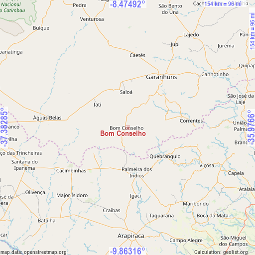
Bom Conselho GPS coordinates[2]
9° 10' 10.992" South, 36° 40' 46.992" West
| Map corner | latitude | longitude |
|---|---|---|
| Upper-left | -8.47492°, | -37.38285° |
| Center: | -9.16972°, | -36.67972° |
| Lower-right: | -9.86316°, | -35.9766° |
| Map W x H: | 154.4×154.4 km | = 95.9×95.9mi |
| max Lat: | 2.81972° ⇑29.4% North |
| Bom Conselho: | -9.16972° |
| min Lat: | ⇓70.6% South -33.69111° |
| min Long | Bom Conselho | max Long |
| -72.89583° | -36.67972° | -32.41083° |
| W 90%⇐ | ⇒10% E |
Elevation
Elevation of Bom Conselho is 655 m = 2149 ft, and this is 274.1 m = 899 ft above average elevation for this country.
| Max E: |
1603 m = 5259 ft | 22.9% |
| Bom Conselho | 655 m 2149 ft | |
| Avg. | 380.9 m = 1250 ft | |
Min E: |
0 m = 0 ft | 77.1% |
See also: Brazil elevation on elevation.city.
Geographical zone
Bom Conselho is located in South Torrid zone (between Equator and Tropic of Capricorn). Distance of Equator is 1019.6 km =633.5 mi to North.| Distance of | km | miles | from Bom Conselho |
|---|---|---|---|
| Equator | 1019.6 | 633.5 | to North |
| Tropic Capricorn | 1586.3 | 985.7 | to South |
| Antarctic Circle | 6381.6 | 3965.3 | to South |
| South Pole | 8987.5 | 5584.6 | to South |


Nearby cities:
15 places around Bom Conselho: (largest is in red/bold)
• Cacimbinhas
42.6 km =26.5 mi,  233°
233°
• Caetés
44.5 km =27.7 mi,  8°
8°
• Capoeiras
48.7 km =30.3 mi, 6°
• Coité do Nóia
52.6 km =32.7 mi,  167°
167°
• Dois Riachos
52.4 km =32.6 mi,  241°
241°
• Garanhuns
37.5 km =23.3 mi,  31°
31°
• Igaci
41.1 km =25.5 mi, 172°
• Major Isidoro
52.4 km =32.6 mi,  219°
219°
• Minador do Negrão
25.3 km =15.7 mi, 233°
• Quebrangulo
28.3 km =17.6 mi,  125°
125°
• Santana do Mundaú
50.2 km =31.2 mi,  89°
89°
• São João
47.5 km =29.5 mi,  46°
46°
• Taquarana
56.5 km =35.1 mi,  159°
159°
• Viçosa
53.1 km =33 mi,  114°
114°
• Águas Belas
49.1 km =30.5 mi,  277°
277°
Sources, notices
• [Note1] Compared only with cities in Brazil existing in our database
• [Src1] Map data: © OpenStreetMap contributors (CC-BY-SA)
• [Src2] Other city data from geonames.org with taken over terms of usage.
• [Src3] Geographical zone / Annual Mean Temperature by Robert A. Rohde @ Wikipedia
