Jucás geodata
Jucás (Ceará) is a populated place; located in Brazil in America/Fortaleza (GMT-3) time zone. With population of 14,821 people, there are 1226 cities with bigger population in this country. Compared to other cities in Brazil, 82.8% of cities are located further ↓South; 77.2% of cities are located further ←West and 56.9% of cities have higher elevation than Jucás. Note1


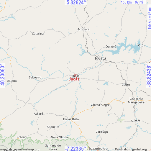
Jucás GPS coordinates[2]
6° 31' 31.008" South, 39° 31' 39" West
| Map corner | latitude | longitude |
|---|---|---|
| Upper-left | -5.82624°, | -40.23063° |
| Center: | -6.52528°, | -39.5275° |
| Lower-right: | -7.22335°, | -38.82438° |
| Map W x H: | 155.3×155.3 km | = 96.5×96.5mi |
| max Lat: | 2.81972° ⇑17.2% North |
| Jucás: | -6.52528° |
| min Lat: | ⇓82.8% South -33.69111° |
| min Long | Jucás | max Long |
| -72.89583° | -39.5275° | -32.41083° |
| W 77.2%⇐ | ⇒22.8% E |
Elevation
Elevation of Jucás is 246 m = 807 ft, and this is 134.9 m = 443 ft below average elevation for this country.
| Max E: |
1603 m = 5259 ft | 56.9% |
| Avg. | 380.9 m = 1250 ft | |
| Jucás | 246 m = 807 ft | |
Min E: |
0 m = 0 ft | 43.1% |
See also: Brazil elevation on elevation.city.
Geographical zone
Jucás is located in South Torrid zone (between Equator and Tropic of Capricorn). Distance of Equator is 725.5 km =450.8 mi to North.| Distance of | km | miles | from Jucás |
|---|---|---|---|
| Equator | 725.5 | 450.8 | to North |
| Tropic Capricorn | 1880.4 | 1168.4 | to South |
| Antarctic Circle | 6675.6 | 4148 | to South |
| South Pole | 9281.5 | 5767.3 | to South |


Nearby cities:
15 places around Jucás: (largest is in red/bold)
• Acopiara
48.5 km =30.1 mi,  9°
9°
• Assaré
54.6 km =33.9 mi,  224°
224°
• Aurora
77.3 km =48 mi,  126°
126°
• Barbalha
90.8 km =56.4 mi,  164°
164°
• Barro
76 km =47.2 mi,  106°
106°
• Caririaçu
63.5 km =39.5 mi,  154°
154°
• Cedro
52.2 km =32.4 mi,  99°
99°
• Crato
79.9 km =49.6 mi,  170°
170°
• Farias Brito
45.3 km =28.1 mi,  185°
185°
• Icó
74.8 km =46.5 mi,  79°
79°
• Iguatu
31.3 km =19.4 mi,  53°
53°
• Juazeiro do Norte
80 km =49.7 mi, 162°
• Lavras da Mangabeira
67.2 km =41.8 mi, 112°
• Mombaça
87.7 km =54.5 mi,  352°
352°
• Orós
74.7 km =46.4 mi,  65°
65°
Sources, notices
• [Note1] Compared only with cities in Brazil existing in our database
• [Src1] Map data: © OpenStreetMap contributors (CC-BY-SA)
• [Src2] Other city data from geonames.org with taken over terms of usage.
• [Src3] Geographical zone / Annual Mean Temperature by Robert A. Rohde @ Wikipedia
