Sete Lagoas geodata
Sete Lagoas (Minas Gerais) is a populated place; located in Brazil in America/Sao_Paulo (GMT-3) time zone. With population of 201,334 people, there are 115 cities with bigger population in this country. Compared to other cities in Brazil, 54.4% of cities are located further ↑North; 54.6% of cities are located further ←West and 85.7% of cities have lower elevation than Sete Lagoas. Note1


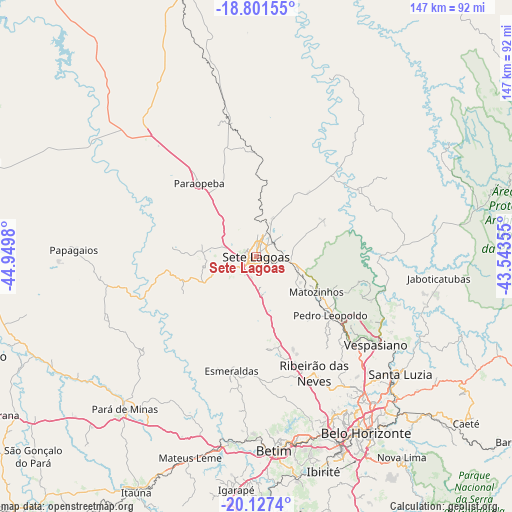
Sete Lagoas GPS coordinates[2]
19° 27' 56.988" South, 44° 14' 48.012" West
| Map corner | latitude | longitude |
|---|---|---|
| Upper-left | -18.80155°, | -44.9498° |
| Center: | -19.46583°, | -44.24667° |
| Lower-right: | -20.1274°, | -43.54355° |
| Map W x H: | 147.4×147.4 km | = 91.6×91.6mi |
| max Lat: | 2.81972° ⇑54.4% North |
| Sete Lagoas: | -19.46583° |
| min Lat: | ⇓45.6% South -33.69111° |
| min Long | Sete Lagoas | max Long |
| -72.89583° | -44.24667° | -32.41083° |
| W 54.6%⇐ | ⇒45.4% E |
Elevation
Elevation of Sete Lagoas is 764 m = 2507 ft, and this is 383.1 m = 1257 ft above average elevation for this country.
| Max E: |
1603 m = 5259 ft | 14.3% |
| Sete Lagoas | 764 m 2507 ft | |
| Avg. | 380.9 m = 1250 ft | |
Min E: |
0 m = 0 ft | 85.7% |
See also: Sete Lagoas elevation on elevation.city.
Geographical zone
Sete Lagoas is located in South Torrid zone (between Equator and Tropic of Capricorn). Distance of this Southern Tropic circle is 441.5 km =274.3 mi to South.| Distance of | km | miles | from Sete Lagoas |
|---|---|---|---|
| Equator | 2164.4 | 1344.9 | to North |
| Tropic Capricorn | 441.5 | 274.3 | to South |
| Antarctic Circle | 5236.8 | 3254 | to South |
| South Pole | 7842.7 | 4873.2 | to South |


Nearby cities:
15 places around Sete Lagoas: (largest is in red/bold)
• Belo Horizonte
60 km =37.3 mi,  147°
147°
• Betim
56 km =34.8 mi,  174°
174°
• Contagem
55.6 km =34.5 mi,  158°
158°
• Esmeraldas
33.7 km =20.9 mi,  192°
192°
• Juatuba
55 km =34.2 mi, 190°
• Lagoa Santa
40.6 km =25.2 mi,  116°
116°
• Mateus Leme
60.9 km =37.8 mi,  198°
198°
• Matozinhos
20.1 km =12.5 mi, 120°
• Papagaios
52.6 km =32.7 mi,  272°
272°
• Pará de Minas
57.9 km =36 mi,  220°
220°
• Pedro Leopoldo
27.2 km =16.9 mi,  128°
128°
• Ribeirão das Neves
37.4 km =23.2 mi, 153°
• Santa Luzia
53.4 km =33.2 mi, 129°
• Sarzedo
64.2 km =39.9 mi, 170°
• Vespasiano
42.2 km =26.2 mi, 126°
Sources, notices
• [Note1] Compared only with cities in Brazil existing in our database
• [Src1] Map data: © OpenStreetMap contributors (CC-BY-SA)
• [Src2] Other city data from geonames.org with taken over terms of usage.
• [Src3] Geographical zone / Annual Mean Temperature by Robert A. Rohde @ Wikipedia
