Esplanada geodata
Esplanada (Bahia) is a populated place; located in Brazil in America/Bahia (GMT-3) time zone. With population of 18,859 people, there are 989 cities with bigger population in this country. Compared to other cities in Brazil, 62.7% of cities are located further ↓South; 84.7% of cities are located further ←West and 66.4% of cities have higher elevation than Esplanada. Note1


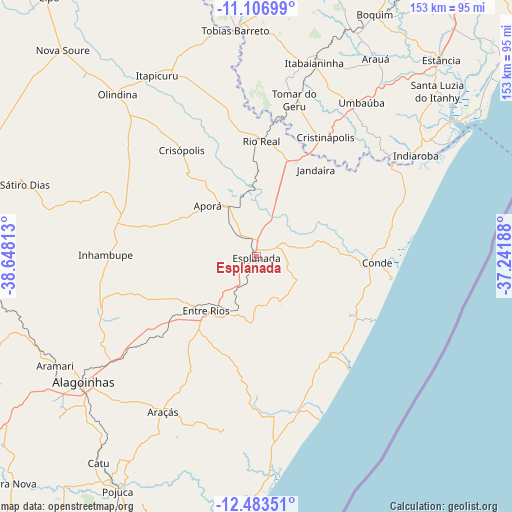
Esplanada GPS coordinates[2]
11° 47' 45.996" South, 37° 56' 42" West
| Map corner | latitude | longitude |
|---|---|---|
| Upper-left | -11.10699°, | -38.64813° |
| Center: | -11.79611°, | -37.945° |
| Lower-right: | -12.48351°, | -37.24188° |
| Map W x H: | 153.1×153.1 km | = 95.1×95.1mi |
| max Lat: | 2.81972° ⇑37.3% North |
| Esplanada: | -11.79611° |
| min Lat: | ⇓62.7% South -33.69111° |
| min Long | Esplanada | max Long |
| -72.89583° | -37.945° | -32.41083° |
| W 84.7%⇐ | ⇒15.3% E |
Elevation
Elevation of Esplanada is 156 m = 512 ft, and this is 224.9 m = 738 ft below average elevation for this country.
| Max E: |
1603 m = 5259 ft | 66.4% |
| Avg. | 380.9 m = 1250 ft | |
| Esplanada | 156 m = 512 ft | |
Min E: |
0 m = 0 ft | 33.6% |
See also: Brazil elevation on elevation.city.
Geographical zone
Esplanada is located in South Torrid zone (between Equator and Tropic of Capricorn). Distance of this Southern Tropic circle is 1294.3 km =804.2 mi to South.| Distance of | km | miles | from Esplanada |
|---|---|---|---|
| Equator | 1311.6 | 815 | to North |
| Tropic Capricorn | 1294.3 | 804.2 | to South |
| Antarctic Circle | 6089.6 | 3783.9 | to South |
| South Pole | 8695.5 | 5403.1 | to South |


Nearby cities:
15 places around Esplanada: (largest is in red/bold)
• Acajutiba
16.8 km =10.4 mi,  332°
332°
• Alagoinhas
63.9 km =39.7 mi,  233°
233°
• Conde
36.5 km =22.7 mi,  93°
93°
• Cristinápolis
41.2 km =25.6 mi,  30°
30°
• Entre Rios
22.2 km =13.8 mi,  223°
223°
• Indiaroba
56.3 km =35 mi,  56°
56°
• Inhambupe
44.4 km =27.6 mi,  271°
271°
• Itabaianinha
60.5 km =37.6 mi,  16°
16°
• Itapicuru
61.9 km =38.5 mi, 329°
• Olindina
63.8 km =39.6 mi,  318°
318°
• Praia do Baixio
44 km =27.3 mi,  141°
141°
• Rio Real
34.6 km =21.5 mi,  2°
2°
• Tobias Barreto
68.3 km =42.4 mi,  355°
355°
• Tomar do Geru
48.4 km =30.1 mi,  13°
13°
• Umbaúba
55.5 km =34.5 mi, 34°
Sources, notices
• [Note1] Compared only with cities in Brazil existing in our database
• [Src1] Map data: © OpenStreetMap contributors (CC-BY-SA)
• [Src2] Other city data from geonames.org with taken over terms of usage.
• [Src3] Geographical zone / Annual Mean Temperature by Robert A. Rohde @ Wikipedia
