Posse geodata
Posse (Goiás) is a populated place; located in Brazil in America/Sao_Paulo (GMT-3) time zone. With population of 20,003 people, there are 939 cities with bigger population in this country. Compared to other cities in Brazil, 58.2% of cities are located further ↓South; 54.2% of cities are located further →East and 90.1% of cities have lower elevation than Posse. Note1


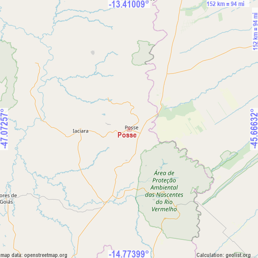
Posse GPS coordinates[2]
14° 5' 35.016" South, 46° 22' 9.984" West
| Map corner | latitude | longitude |
|---|---|---|
| Upper-left | -13.41009°, | -47.07257° |
| Center: | -14.09306°, | -46.36944° |
| Lower-right: | -14.77399°, | -45.66632° |
| Map W x H: | 151.7×151.7 km | = 94.3×94.3mi |
| max Lat: | 2.81972° ⇑41.8% North |
| Posse: | -14.09306° |
| min Lat: | ⇓58.2% South -33.69111° |
| min Long | Posse | max Long |
| -72.89583° | -46.36944° | -32.41083° |
| W 45.8%⇐ | ⇒54.2% E |
Elevation
Elevation of Posse is 815 m = 2674 ft, and this is 434.1 m = 1424 ft above average elevation for this country.
| Max E: |
1603 m = 5259 ft | 9.9% |
| Posse | 815 m 2674 ft | |
| Avg. | 380.9 m = 1250 ft | |
Min E: |
0 m = 0 ft | 90.1% |
See also: Brazil elevation on elevation.city.
Geographical zone
Posse is located in South Torrid zone (between Equator and Tropic of Capricorn). Distance of this Southern Tropic circle is 1038.9 km =645.5 mi to South.| Distance of | km | miles | from Posse |
|---|---|---|---|
| Equator | 1567 | 973.7 | to North |
| Tropic Capricorn | 1038.9 | 645.5 | to South |
| Antarctic Circle | 5834.2 | 3625.2 | to South |
| South Pole | 8440.1 | 5244.4 | to South |


Nearby cities:
15 places around Posse: (largest is in red/bold)
• Arinos
204.8 km =127.3 mi,  172°
172°
• Arraias
143.1 km =88.9 mi,  334°
334°
• Buritis
169.6 km =105.4 mi,  181°
181°
• Campos Belos
125.2 km =77.8 mi,  339°
339°
• Cavalcante
122 km =75.8 mi,  285°
285°
• Correntina
204.9 km =127.3 mi,  65°
65°
• Formosa
191.2 km =118.8 mi,  212°
212°
• Iaciara
28.3 km =17.6 mi,  269°
269°
• Minaçu
209.3 km =130.1 mi, 287°
• Niquelândia
229.2 km =142.4 mi,  259°
259°
• Padre Bernardo
237.9 km =147.8 mi,  239°
239°
• Planaltina
201.9 km =125.5 mi,  221°
221°
• Planaltina
218.3 km =135.6 mi, 219°
• São Domingos
77.4 km =48.1 mi,  4°
4°
• Taguatinga
188 km =116.8 mi,  357°
357°
Sources, notices
• [Note1] Compared only with cities in Brazil existing in our database
• [Src1] Map data: © OpenStreetMap contributors (CC-BY-SA)
• [Src2] Other city data from geonames.org with taken over terms of usage.
• [Src3] Geographical zone / Annual Mean Temperature by Robert A. Rohde @ Wikipedia
