Santo Estêvão geodata
Santo Estêvão (Bahia) is a populated place; located in Brazil in America/Bahia (GMT-3) time zone. With population of 27,279 people, there are 725 cities with bigger population in this country. Compared to other cities in Brazil, 61.4% of cities are located further ↓South; 78.9% of cities are located further ←West and 57.2% of cities have higher elevation than Santo Estêvão. Note1


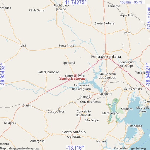
Santo Estêvão GPS coordinates[2]
12° 25' 49.008" South, 39° 15' 5.004" West
| Map corner | latitude | longitude |
|---|---|---|
| Upper-left | -11.74275°, | -39.95452° |
| Center: | -12.43028°, | -39.25139° |
| Lower-right: | -13.116°, | -38.54827° |
| Map W x H: | 152.7×152.7 km | = 94.9×94.9mi |
| max Lat: | 2.81972° ⇑38.6% North |
| Santo Estêvão: | -12.43028° |
| min Lat: | ⇓61.4% South -33.69111° |
| min Long | Santo Estêvão | max Long |
| -72.89583° | -39.25139° | -32.41083° |
| W 78.9%⇐ | ⇒21.1% E |
Elevation
Elevation of Santo Estêvão is 242 m = 794 ft, and this is 138.9 m = 456 ft below average elevation for this country.
| Max E: |
1603 m = 5259 ft | 57.2% |
| Avg. | 380.9 m = 1250 ft | |
| Santo Estêvão | 242 m = 794 ft | |
Min E: |
0 m = 0 ft | 42.8% |
See also: Brazil elevation on elevation.city.
Geographical zone
Santo Estêvão is located in South Torrid zone (between Equator and Tropic of Capricorn). Distance of this Southern Tropic circle is 1223.8 km =760.4 mi to South.| Distance of | km | miles | from Santo Estêvão |
|---|---|---|---|
| Equator | 1382.1 | 858.8 | to North |
| Tropic Capricorn | 1223.8 | 760.4 | to South |
| Antarctic Circle | 6019.1 | 3740.1 | to South |
| South Pole | 8624.9 | 5359.3 | to South |


Nearby cities:
15 places around Santo Estêvão: (largest is in red/bold)
• Anguera
31 km =19.3 mi,  1°
1°
• Cachoeira
36.4 km =22.6 mi,  121°
121°
• Castro Alves
41.9 km =26 mi,  207°
207°
• Conceição da Feira
28.7 km =17.8 mi,  107°
107°
• Conceição do Almeida
39.8 km =24.7 mi,  167°
167°
• Conceição do Jacuípe
54.1 km =33.6 mi,  76°
76°
• Coração de Maria
58.7 km =36.5 mi,  68°
68°
• Cruz das Almas
31.2 km =19.4 mi,  148°
148°
• Feira de Santana
35.9 km =22.3 mi,  59°
59°
• Maragogipe
52.8 km =32.8 mi,  137°
137°
• Muritiba
54.1 km =33.6 mi,  179°
179°
• Santo Amaro
60 km =37.3 mi,  102°
102°
• Santo Antônio de Jesus
59.9 km =37.2 mi, 181°
• Sobradinho
47.7 km =29.6 mi,  159°
159°
• São Gonçalo dos Campos
30.9 km =19.2 mi,  90°
90°
Sources, notices
• [Note1] Compared only with cities in Brazil existing in our database
• [Src1] Map data: © OpenStreetMap contributors (CC-BY-SA)
• [Src2] Other city data from geonames.org with taken over terms of usage.
• [Src3] Geographical zone / Annual Mean Temperature by Robert A. Rohde @ Wikipedia
