Anguera geodata
Anguera (Bahia) is a populated place; located in Brazil in America/Bahia (GMT-3) time zone. With population of 10,242 people, there are 1630 cities with bigger population in this country. Compared to other cities in Brazil, 62.2% of cities are located further ↓South; 79% of cities are located further ←West and 57.7% of cities have higher elevation than Anguera. Note1


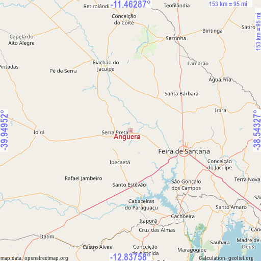
Anguera GPS coordinates[2]
12° 9' 3.996" South, 39° 14' 47.004" West
| Map corner | latitude | longitude |
|---|---|---|
| Upper-left | -11.46287°, | -39.94952° |
| Center: | -12.15111°, | -39.24639° |
| Lower-right: | -12.83758°, | -38.54327° |
| Map W x H: | 152.9×152.9 km | = 95×95mi |
| max Lat: | 2.81972° ⇑37.8% North |
| Anguera: | -12.15111° |
| min Lat: | ⇓62.2% South -33.69111° |
| min Long | Anguera | max Long |
| -72.89583° | -39.24639° | -32.41083° |
| W 79%⇐ | ⇒21% E |
Elevation
Elevation of Anguera is 238 m = 781 ft, and this is 142.9 m = 469 ft below average elevation for this country.
| Max E: |
1603 m = 5259 ft | 57.7% |
| Avg. | 380.9 m = 1250 ft | |
| Anguera | 238 m = 781 ft | |
Min E: |
0 m = 0 ft | 42.3% |
See also: Brazil elevation on elevation.city.
Geographical zone
Anguera is located in South Torrid zone (between Equator and Tropic of Capricorn). Distance of this Southern Tropic circle is 1254.8 km =779.7 mi to South.| Distance of | km | miles | from Anguera |
|---|---|---|---|
| Equator | 1351.1 | 839.5 | to North |
| Tropic Capricorn | 1254.8 | 779.7 | to South |
| Antarctic Circle | 6050.1 | 3759.4 | to South |
| South Pole | 8656 | 5378.6 | to South |


Nearby cities:
15 places around Anguera: (largest is in red/bold)
• Cachoeira
58.6 km =36.4 mi,  148°
148°
• Castro Alves
71.1 km =44.2 mi,  196°
196°
• Conceição da Feira
47.7 km =29.6 mi, 145°
• Conceição do Almeida
70.4 km =43.7 mi,  173°
173°
• Conceição do Coité
65.4 km =40.6 mi,  356°
356°
• Conceição do Jacuípe
55.3 km =34.4 mi,  109°
109°
• Coração de Maria
54.7 km =34 mi,  99°
99°
• Cruz das Almas
59.8 km =37.2 mi,  164°
164°
• Feira de Santana
33 km =20.5 mi, 112°
• Ipirá
53.4 km =33.2 mi,  269°
269°
• Irará
53.4 km =33.2 mi,  77°
77°
• Riachão do Jacuípe
41.2 km =25.6 mi,  338°
338°
• Santo Estêvão
31 km =19.3 mi,  181°
181°
• Serrinha
60.1 km =37.3 mi,  25°
25°
• São Gonçalo dos Campos
43.7 km =27.2 mi,  135°
135°
Sources, notices
• [Note1] Compared only with cities in Brazil existing in our database
• [Src1] Map data: © OpenStreetMap contributors (CC-BY-SA)
• [Src2] Other city data from geonames.org with taken over terms of usage.
• [Src3] Geographical zone / Annual Mean Temperature by Robert A. Rohde @ Wikipedia
