Castro Alves geodata
Castro Alves (Bahia) is a populated place; located in Brazil in America/Bahia (GMT-3) time zone. With population of 13,868 people, there are 1300 cities with bigger population in this country. Compared to other cities in Brazil, 60.5% of cities are located further ↓South; 77.6% of cities are located further ←West and 55.9% of cities have higher elevation than Castro Alves. Note1


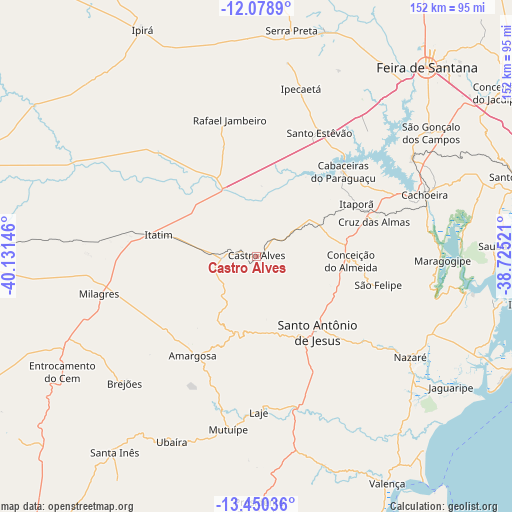
Castro Alves GPS coordinates[2]
12° 45' 56.016" South, 39° 25' 41.988" West
| Map corner | latitude | longitude |
|---|---|---|
| Upper-left | -12.0789°, | -40.13146° |
| Center: | -12.76556°, | -39.42833° |
| Lower-right: | -13.45036°, | -38.72521° |
| Map W x H: | 152.5×152.5 km | = 94.8×94.8mi |
| max Lat: | 2.81972° ⇑39.5% North |
| Castro Alves: | -12.76556° |
| min Lat: | ⇓60.5% South -33.69111° |
| min Long | Castro Alves | max Long |
| -72.89583° | -39.42833° | -32.41083° |
| W 77.6%⇐ | ⇒22.4% E |
Elevation
Elevation of Castro Alves is 255 m = 837 ft, and this is 125.9 m = 413 ft below average elevation for this country.
| Max E: |
1603 m = 5259 ft | 55.9% |
| Avg. | 380.9 m = 1250 ft | |
| Castro Alves | 255 m = 837 ft | |
Min E: |
0 m = 0 ft | 44.1% |
See also: Brazil elevation on elevation.city.
Geographical zone
Castro Alves is located in South Torrid zone (between Equator and Tropic of Capricorn). Distance of this Southern Tropic circle is 1186.5 km =737.3 mi to South.| Distance of | km | miles | from Castro Alves |
|---|---|---|---|
| Equator | 1419.4 | 882 | to North |
| Tropic Capricorn | 1186.5 | 737.3 | to South |
| Antarctic Circle | 5981.8 | 3716.9 | to South |
| South Pole | 8587.7 | 5336.1 | to South |


Nearby cities:
15 places around Castro Alves: (largest is in red/bold)
• Amargosa
35.1 km =21.8 mi,  213°
213°
• Anguera
71.1 km =44.2 mi,  16°
16°
• Cachoeira
53.4 km =33.2 mi,  70°
70°
• Conceição da Feira
54.8 km =34.1 mi,  58°
58°
• Conceição do Almeida
28.1 km =17.5 mi,  93°
93°
• Cruz das Almas
37 km =23 mi, 73°
• Maragogipe
55.2 km =34.3 mi, 91°
• Muritiba
25.6 km =15.9 mi,  130°
130°
• Mutuípe
52.1 km =32.4 mi,  189°
189°
• Nazaré
53.9 km =33.5 mi,  123°
123°
• Santo Antônio de Jesus
29 km =18 mi,  141°
141°
• Santo Estêvão
41.9 km =26 mi,  27°
27°
• Sobradinho
36.4 km =22.6 mi,  101°
101°
• São Gonçalo dos Campos
62.2 km =38.6 mi,  53°
53°
• Ubaíra
61.4 km =38.2 mi,  204°
204°
Sources, notices
• [Note1] Compared only with cities in Brazil existing in our database
• [Src1] Map data: © OpenStreetMap contributors (CC-BY-SA)
• [Src2] Other city data from geonames.org with taken over terms of usage.
• [Src3] Geographical zone / Annual Mean Temperature by Robert A. Rohde @ Wikipedia
