Porto Feliz geodata
Porto Feliz (São Paulo) is a seat of a second-order administrative division; located in Brazil in America/Sao_Paulo (GMT-3) time zone. With population of 41,015 people, there are 515 cities with bigger population in this country. Compared to other cities in Brazil, 80.5% of cities are located further ↑North; 62% of cities are located further →East and 66.6% of cities have lower elevation than Porto Feliz. Note1


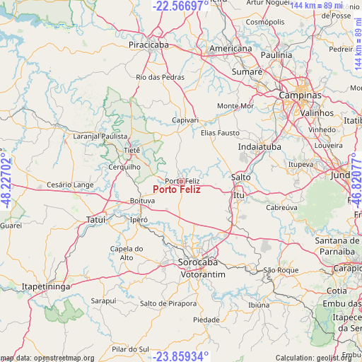
Porto Feliz GPS coordinates[2]
23° 12' 52.992" South, 47° 31' 26.004" West
| Map corner | latitude | longitude |
|---|---|---|
| Upper-left | -22.56697°, | -48.22702° |
| Center: | -23.21472°, | -47.52389° |
| Lower-right: | -23.85934°, | -46.82077° |
| Map W x H: | 143.7×143.7 km | = 89.3×89.3mi |
| max Lat: | 2.81972° ⇑80.5% North |
| Porto Feliz: | -23.21472° |
| min Lat: | ⇓19.5% South -33.69111° |
| min Long | Porto Feliz | max Long |
| -72.89583° | -47.52389° | -32.41083° |
| W 38%⇐ | ⇒62% E |
Elevation
Elevation of Porto Feliz is 541 m = 1775 ft, and this is 160.1 m = 525 ft above average elevation for this country.
| Max E: |
1603 m = 5259 ft | 33.4% |
| Porto Feliz | 541 m 1775 ft | |
| Avg. | 380.9 m = 1250 ft | |
Min E: |
0 m = 0 ft | 66.6% |
See also: Porto Feliz elevation on elevation.city.
Geographical zone
Porto Feliz is located in South Torrid zone (between Equator and Tropic of Capricorn). Distance of this Southern Tropic circle is 24.7 km =15.3 mi to South.| Distance of | km | miles | from Porto Feliz |
|---|---|---|---|
| Equator | 2581.2 | 1603.9 | to North |
| Tropic Capricorn | 24.7 | 15.3 | to South |
| Antarctic Circle | 4819.9 | 2994.9 | to South |
| South Pole | 7425.8 | 4614.2 | to South |


Nearby cities:
15 places around Porto Feliz: (largest is in red/bold)
• Araçoiaba da Serra
33.6 km =20.9 mi,  195°
195°
• Boituva
17 km =10.6 mi,  243°
243°
• Capela do Alto
35.7 km =22.2 mi,  217°
217°
• Capivari
24.5 km =15.2 mi,  3°
3°
• Cerquilho
23.1 km =14.4 mi,  283°
283°
• Elias Fausto
24.5 km =15.2 mi,  38°
38°
• Indaiatuba
34.9 km =21.7 mi,  66°
66°
• Iperó
22.6 km =14 mi,  228°
228°
• Itu
23.6 km =14.7 mi,  103°
103°
• Laranjal Paulista
36.9 km =22.9 mi,  299°
299°
• Monte Mor
36.6 km =22.7 mi, 35°
• Salto
24.3 km =15.1 mi,  86°
86°
• Sorocaba
32.6 km =20.3 mi,  168°
168°
• Tatuí
37.4 km =23.2 mi,  245°
245°
• Tietê
23.2 km =14.4 mi, 302°
Sources, notices
• [Note1] Compared only with cities in Brazil existing in our database
• [Src1] Map data: © OpenStreetMap contributors (CC-BY-SA)
• [Src2] Other city data from geonames.org with taken over terms of usage.
• [Src3] Geographical zone / Annual Mean Temperature by Robert A. Rohde @ Wikipedia
