Presidente Venceslau geodata
Presidente Venceslau (São Paulo) is a populated place; located in Brazil in America/Sao_Paulo (GMT-3) time zone. With population of 34,026 people, there are 607 cities with bigger population in this country. Compared to other cities in Brazil, 69.3% of cities are located further ↑North; 87.1% of cities are located further →East and 55.8% of cities have lower elevation than Presidente Venceslau. Note1


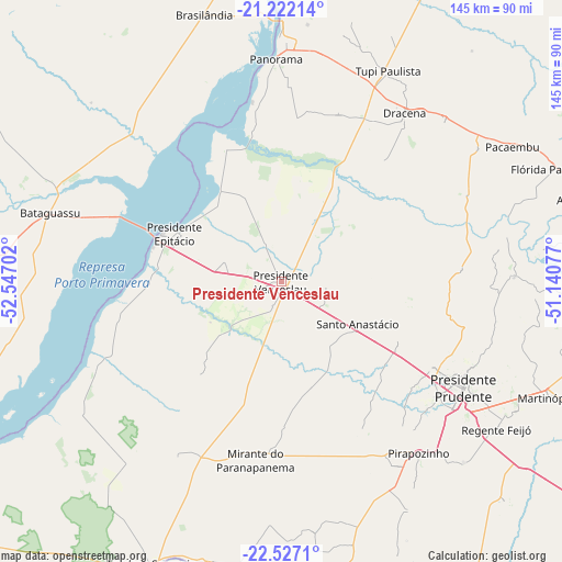
Presidente Venceslau GPS coordinates[2]
21° 52' 33.996" South, 51° 50' 38.004" West
| Map corner | latitude | longitude |
|---|---|---|
| Upper-left | -21.22214°, | -52.54702° |
| Center: | -21.87611°, | -51.84389° |
| Lower-right: | -22.5271°, | -51.14077° |
| Map W x H: | 145.1×145.1 km | = 90.2×90.2mi |
| max Lat: | 2.81972° ⇑69.3% North |
| Presidente Venceslau: | -21.87611° |
| min Lat: | ⇓30.7% South -33.69111° |
| min Long | Presidente Venc | max Long |
| -72.89583° | -51.84389° | -32.41083° |
| W 12.9%⇐ | ⇒87.1% E |
Elevation
Elevation of Presidente Venceslau is 428 m = 1404 ft, and this is 47.1 m = 155 ft above average elevation for this country.
| Max E: |
1603 m = 5259 ft | 44.2% |
| Presidente Venceslau | 428 m 1404 ft | |
| Avg. | 380.9 m = 1250 ft | |
Min E: |
0 m = 0 ft | 55.8% |
See also: Brazil elevation on elevation.city.
Geographical zone
Presidente Venceslau is located in South Torrid zone (between Equator and Tropic of Capricorn). Distance of this Southern Tropic circle is 173.5 km =107.8 mi to South.| Distance of | km | miles | from Presidente Venceslau |
|---|---|---|---|
| Equator | 2432.4 | 1511.4 | to North |
| Tropic Capricorn | 173.5 | 107.8 | to South |
| Antarctic Circle | 4968.8 | 3087.5 | to South |
| South Pole | 7574.7 | 4706.7 | to South |


Nearby cities:
15 places around Presidente Venceslau: (largest is in red/bold)
• Junqueirópolis
58.4 km =36.3 mi,  46°
46°
• Martinópolis
75.6 km =47 mi,  113°
113°
• Mirante do Paranapanema
46.7 km =29 mi,  187°
187°
• Pacaembu
69.6 km =43.2 mi,  59°
59°
• Panorama
57.8 km =35.9 mi,  358°
358°
• Paulista Flórida
73.2 km =45.5 mi,  65°
65°
• Pirapozinho
56.8 km =35.3 mi,  141°
141°
• Presidente Bernardes
33.3 km =20.7 mi,  115°
115°
• Presidente Epitácio
30.7 km =19.1 mi,  294°
294°
• Presidente Prudente
54.5 km =33.9 mi, 120°
• Regente Feijó
67.7 km =42.1 mi, 124°
• Santo Anastácio
24.5 km =15.2 mi,  80°
80°
• Teodoro Sampaio
80.2 km =49.8 mi,  204°
204°
• Tupi Paulista
61.9 km =38.5 mi,  27°
27°
• Álvares Machado
44.5 km =27.7 mi, 120°
Sources, notices
• [Note1] Compared only with cities in Brazil existing in our database
• [Src1] Map data: © OpenStreetMap contributors (CC-BY-SA)
• [Src2] Other city data from geonames.org with taken over terms of usage.
• [Src3] Geographical zone / Annual Mean Temperature by Robert A. Rohde @ Wikipedia
