Mirante do Paranapanema geodata
Mirante do Paranapanema (São Paulo) is a populated place; located in Brazil in America/Sao_Paulo (GMT-3) time zone. With population of 9,387 people, there are 1695 cities with bigger population in this country. Compared to other cities in Brazil, 71.9% of cities are located further ↑North; 87.4% of cities are located further →East and 57.5% of cities have lower elevation than Mirante do Paranapanema. Note1
Current local time in Mirante do Paranapanema:
06:50 PM, TuesdayDifference from your time zone: hours


Mirante do Paranapanema GPS coordinates[2]
22° 17' 30.984" South, 51° 54' 23.004" West
| Map corner | latitude | longitude |
|---|---|---|
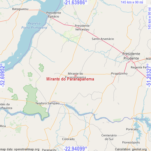
| Upper-left | -21.63986°, | -52.60952° |
| Center: | -22.29194°, | -51.90639° |
| Lower-right: | -22.94099°, | -51.20327° |
| Map W x H: | 144.7×144.7 km | = 89.9×89.9mi |
| max Lat: | 2.81972° ⇑71.9% North |
| Mirante do Paranapanema: | -22.29194° |
| min Lat: | ⇓28.1% South -33.69111° |
| min Long | Mirante do Para | max Long |
| -72.89583° | -51.90639° | -32.41083° |
| W 12.6%⇐ | ⇒87.4% E |
Elevation
Elevation of Mirante do Paranapanema is 446 m = 1463 ft, and this is 65.1 m = 214 ft above average elevation for this country.
| Max E: |
1603 m = 5259 ft | 42.5% |
| Mirante do Paranapanema | 446 m 1463 ft | |
| Avg. | 380.9 m = 1250 ft | |
Min E: |
0 m = 0 ft | 57.5% |
See also: Brazil elevation on elevation.city.
Geographical zone
Mirante do Paranapanema is located in South Torrid zone (between Equator and Tropic of Capricorn). Distance of this Southern Tropic circle is 127.3 km =79.1 mi to South.| Distance of | km | miles | from Mirante do Paranapanema |
|---|---|---|---|
| Equator | 2478.6 | 1540.1 | to North |
| Tropic Capricorn | 127.3 | 79.1 | to South |
| Antarctic Circle | 4922.5 | 3058.7 | to South |
| South Pole | 7528.4 | 4677.9 | to South |


Nearby cities:
15 places around Mirante do Paranapanema: (largest is in red/bold)
• Centenário do Sul
67 km =41.6 mi,  151°
151°
• Colorado
61 km =37.9 mi,  186°
186°
• Florestópolis
82.9 km =51.5 mi,  140°
140°
• Martinópolis
77.4 km =48.1 mi,  77°
77°
• Pirapozinho
41.9 km =26 mi,  87°
87°
• Porecatu
74.8 km =46.5 mi,  133°
133°
• Presidente Bernardes
48.3 km =30 mi,  48°
48°
• Presidente Epitácio
62.6 km =38.9 mi,  339°
339°
• Presidente Prudente
56.4 km =35 mi,  70°
70°
• Presidente Venceslau
46.7 km =29 mi,  7°
7°
• Regente Feijó
62.6 km =38.9 mi, 82°
• Santo Anastácio
58.9 km =36.6 mi,  31°
31°
• Teodoro Sampaio
37.9 km =23.5 mi,  225°
225°
• Terra Rica
86.5 km =53.7 mi,  237°
237°
• Álvares Machado
50.6 km =31.4 mi,  62°
62°
Sources, notices
• [Note1] Compared only with cities in Brazil existing in our database
• [Src1] Map data: © OpenStreetMap contributors (CC-BY-SA)
• [Src2] Other city data from geonames.org with taken over terms of usage.
• [Src3] Geographical zone / Annual Mean Temperature by Robert A. Rohde @ Wikipedia
