Pirapozinho geodata
Pirapozinho (São Paulo) is a populated place; located in Brazil in America/Sao_Paulo (GMT-3) time zone. With population of 21,709 people, there are 879 cities with bigger population in this country. Compared to other cities in Brazil, 71.7% of cities are located further ↑North; 85.5% of cities are located further →East and 61.5% of cities have lower elevation than Pirapozinho. Note1


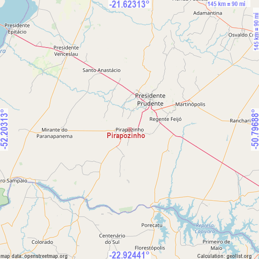
Pirapozinho GPS coordinates[2]
22° 16' 31.008" South, 51° 30' 0" West
| Map corner | latitude | longitude |
|---|---|---|
| Upper-left | -21.62313°, | -52.20313° |
| Center: | -22.27528°, | -51.5° |
| Lower-right: | -22.92441°, | -50.79688° |
| Map W x H: | 144.7×144.7 km | = 89.9×89.9mi |
| max Lat: | 2.81972° ⇑71.7% North |
| Pirapozinho: | -22.27528° |
| min Lat: | ⇓28.3% South -33.69111° |
| min Long | Pirapozinho | max Long |
| -72.89583° | -51.5° | -32.41083° |
| W 14.5%⇐ | ⇒85.5% E |
Elevation
Elevation of Pirapozinho is 491 m = 1611 ft, and this is 110.1 m = 361 ft above average elevation for this country.
| Max E: |
1603 m = 5259 ft | 38.5% |
| Pirapozinho | 491 m 1611 ft | |
| Avg. | 380.9 m = 1250 ft | |
Min E: |
0 m = 0 ft | 61.5% |
See also: Brazil elevation on elevation.city.
Geographical zone
Pirapozinho is located in South Torrid zone (between Equator and Tropic of Capricorn). Distance of this Southern Tropic circle is 129.1 km =80.2 mi to South.| Distance of | km | miles | from Pirapozinho |
|---|---|---|---|
| Equator | 2476.8 | 1539 | to North |
| Tropic Capricorn | 129.1 | 80.2 | to South |
| Antarctic Circle | 4924.4 | 3059.9 | to South |
| South Pole | 7530.3 | 4679.1 | to South |


Nearby cities:
15 places around Pirapozinho: (largest is in red/bold)
• Adamantina
79 km =49.1 mi,  33°
33°
• Centenário do Sul
61.5 km =38.2 mi,  189°
189°
• Florestópolis
66.4 km =41.3 mi,  169°
169°
• Lucélia
79.2 km =49.2 mi,  38°
38°
• Martinópolis
36.8 km =22.9 mi,  66°
66°
• Mirante do Paranapanema
41.9 km =26 mi,  267°
267°
• Porecatu
54.9 km =34.1 mi, 166°
• Presidente Bernardes
30.4 km =18.9 mi,  349°
349°
• Presidente Prudente
20.2 km =12.6 mi, 34°
• Presidente Venceslau
56.8 km =35.3 mi,  321°
321°
• Rancharia
62.7 km =39 mi,  85°
85°
• Regente Feijó
21.2 km =13.2 mi, 73°
• Santo Anastácio
49.9 km =31 mi, 346°
• Teodoro Sampaio
74.3 km =46.2 mi,  247°
247°
• Álvares Machado
22 km =13.7 mi,  7°
7°
Sources, notices
• [Note1] Compared only with cities in Brazil existing in our database
• [Src1] Map data: © OpenStreetMap contributors (CC-BY-SA)
• [Src2] Other city data from geonames.org with taken over terms of usage.
• [Src3] Geographical zone / Annual Mean Temperature by Robert A. Rohde @ Wikipedia
