Regente Feijó geodata
Regente Feijó (São Paulo) is a populated place; located in Brazil in America/Sao_Paulo (GMT-3) time zone. With population of 17,218 people, there are 1082 cities with bigger population in this country. Compared to other cities in Brazil, 71.2% of cities are located further ↑North; 84.4% of cities are located further →East and 63.3% of cities have lower elevation than Regente Feijó. Note1


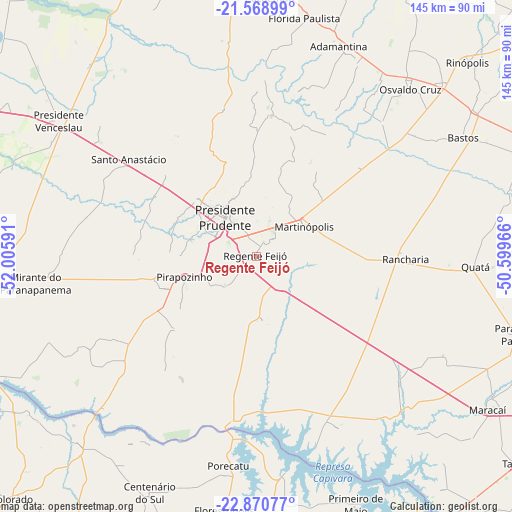
Regente Feijó GPS coordinates[2]
22° 13' 17.004" South, 51° 18' 10.008" West
| Map corner | latitude | longitude |
|---|---|---|
| Upper-left | -21.56899°, | -52.00591° |
| Center: | -22.22139°, | -51.30278° |
| Lower-right: | -22.87077°, | -50.59966° |
| Map W x H: | 144.7×144.7 km | = 89.9×89.9mi |
| max Lat: | 2.81972° ⇑71.2% North |
| Regente Feijó: | -22.22139° |
| min Lat: | ⇓28.8% South -33.69111° |
| min Long | Regente Feijó | max Long |
| -72.89583° | -51.30278° | -32.41083° |
| W 15.6%⇐ | ⇒84.4% E |
Elevation
Elevation of Regente Feijó is 511 m = 1677 ft, and this is 130.1 m = 427 ft above average elevation for this country.
| Max E: |
1603 m = 5259 ft | 36.7% |
| Regente Feijó | 511 m 1677 ft | |
| Avg. | 380.9 m = 1250 ft | |
Min E: |
0 m = 0 ft | 63.3% |
See also: Brazil elevation on elevation.city.
Geographical zone
Regente Feijó is located in South Torrid zone (between Equator and Tropic of Capricorn). Distance of this Southern Tropic circle is 135.1 km =83.9 mi to South.| Distance of | km | miles | from Regente Feijó |
|---|---|---|---|
| Equator | 2470.8 | 1535.3 | to North |
| Tropic Capricorn | 135.1 | 83.9 | to South |
| Antarctic Circle | 4930.4 | 3063.6 | to South |
| South Pole | 7536.3 | 4682.8 | to South |


Nearby cities:
15 places around Regente Feijó: (largest is in red/bold)
• Adamantina
64.2 km =39.9 mi,  21°
21°
• Bastos
67.4 km =41.9 mi,  60°
60°
• Lucélia
62.9 km =39.1 mi,  27°
27°
• Martinópolis
16 km =9.9 mi, 58°
• Mirante do Paranapanema
62.6 km =38.9 mi,  262°
262°
• Osvaldo Cruz
64.4 km =40 mi,  42°
42°
• Pirapozinho
21.2 km =13.2 mi,  253°
253°
• Porecatu
59.9 km =37.2 mi,  187°
187°
• Presidente Bernardes
35.2 km =21.9 mi,  312°
312°
• Presidente Prudente
13.9 km =8.6 mi,  320°
320°
• Presidente Venceslau
67.7 km =42.1 mi,  304°
304°
• Quatá
62.3 km =38.7 mi,  92°
92°
• Rancharia
42.2 km =26.2 mi, 91°
• Santo Anastácio
53.1 km =33 mi, 323°
• Álvares Machado
23.5 km =14.6 mi, 312°
Sources, notices
• [Note1] Compared only with cities in Brazil existing in our database
• [Src1] Map data: © OpenStreetMap contributors (CC-BY-SA)
• [Src2] Other city data from geonames.org with taken over terms of usage.
• [Src3] Geographical zone / Annual Mean Temperature by Robert A. Rohde @ Wikipedia
