Porto Murtinho geodata
Porto Murtinho (Mato Grosso do Sul) is a populated place; located in Brazil in America/Campo_Grande (GMT-4) time zone. With population of 12,667 people, there are 1400 cities with bigger population in this country. Compared to other cities in Brazil, 67.9% of cities are located further ↑North; 96.8% of cities are located further →East and 74.8% of cities have higher elevation than Porto Murtinho. Note1


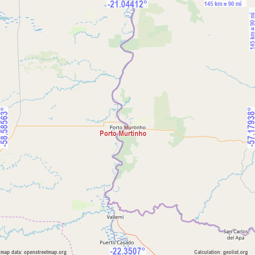
Porto Murtinho GPS coordinates[2]
21° 41' 56.004" South, 57° 52' 57" West
| Map corner | latitude | longitude |
|---|---|---|
| Upper-left | -21.04412°, | -58.58563° |
| Center: | -21.69889°, | -57.8825° |
| Lower-right: | -22.3507°, | -57.17938° |
| Map W x H: | 145.3×145.3 km | = 90.3×90.3mi |
| max Lat: | 2.81972° ⇑67.9% North |
| Porto Murtinho: | -21.69889° |
| min Lat: | ⇓32.1% South -33.69111° |
| min Long | Porto Murtinho | max Long |
| -72.89583° | -57.8825° | -32.41083° |
| W 3.2%⇐ | ⇒96.8% E |
Elevation
Elevation of Porto Murtinho is 79 m = 259 ft, and this is 301.9 m = 990 ft below average elevation for this country.
| Max E: |
1603 m = 5259 ft | 74.8% |
| Avg. | 380.9 m = 1250 ft | |
| Porto Murtinho | 79 m = 259 ft | |
Min E: |
0 m = 0 ft | 25.2% |
See also: Brazil elevation on elevation.city.
Geographical zone
Porto Murtinho is located in South Torrid zone (between Equator and Tropic of Capricorn). Distance of this Southern Tropic circle is 193.2 km =120 mi to South.| Distance of | km | miles | from Porto Murtinho |
|---|---|---|---|
| Equator | 2412.7 | 1499.2 | to North |
| Tropic Capricorn | 193.2 | 120 | to South |
| Antarctic Circle | 4988.5 | 3099.7 | to South |
| South Pole | 7594.4 | 4718.9 | to South |


Nearby cities:
15 places around Porto Murtinho: (largest is in red/bold)
• Anastácio
254.2 km =158 mi,  57°
57°
• Aquidauana
256.7 km =159.5 mi, 57°
• Bela Vista
147.7 km =91.8 mi,  107°
107°
• Bonito
158.6 km =98.5 mi,  66°
66°
• Caarapó
331.8 km =206.2 mi, 108°
• Corumbá
300 km =186.4 mi,  4°
4°
• Dourados
322.6 km =200.5 mi,  100°
100°
• Guia Lopes da Laguna
184.8 km =114.8 mi,  81°
81°
• Jardim
182 km =113.1 mi, 82°
• Ladário
301 km =187 mi,  5°
5°
• Maracaju
280.6 km =174.4 mi,  88°
88°
• Miranda
225.1 km =139.9 mi,  43°
43°
• Ponta Porã
240.9 km =149.7 mi, 112°
• Sidrolândia
314.4 km =195.4 mi, 74°
• Terenos
343.3 km =213.3 mi, 65°
Sources, notices
• [Note1] Compared only with cities in Brazil existing in our database
• [Src1] Map data: © OpenStreetMap contributors (CC-BY-SA)
• [Src2] Other city data from geonames.org with taken over terms of usage.
• [Src3] Geographical zone / Annual Mean Temperature by Robert A. Rohde @ Wikipedia
