Ladário geodata
Ladário (Mato Grosso do Sul) is a populated place; located in Brazil in America/Campo_Grande (GMT-4) time zone. With population of 15,790 people, there are 1169 cities with bigger population in this country. Compared to other cities in Brazil, 53.3% of cities are located further ↑North; 96.5% of cities are located further →East and 69.7% of cities have higher elevation than Ladário. Note1


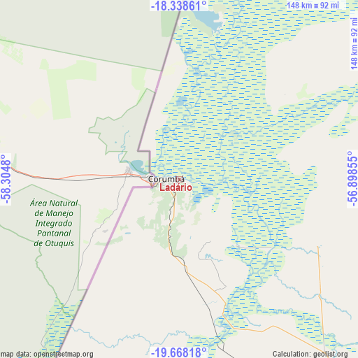
Ladário GPS coordinates[2]
19° 0' 16.992" South, 57° 36' 6.012" West
| Map corner | latitude | longitude |
|---|---|---|
| Upper-left | -18.33861°, | -58.3048° |
| Center: | -19.00472°, | -57.60167° |
| Lower-right: | -19.66818°, | -56.89855° |
| Map W x H: | 147.8×147.8 km | = 91.8×91.8mi |
| max Lat: | 2.81972° ⇑53.3% North |
| Ladário: | -19.00472° |
| min Lat: | ⇓46.7% South -33.69111° |
| min Long | Ladário | max Long |
| -72.89583° | -57.60167° | -32.41083° |
| W 3.5%⇐ | ⇒96.5% E |
Elevation
Elevation of Ladário is 126 m = 413 ft, and this is 254.9 m = 836 ft below average elevation for this country.
| Max E: |
1603 m = 5259 ft | 69.7% |
| Avg. | 380.9 m = 1250 ft | |
| Ladário | 126 m = 413 ft | |
Min E: |
0 m = 0 ft | 30.3% |
See also: Brazil elevation on elevation.city.
Geographical zone
Ladário is located in South Torrid zone (between Equator and Tropic of Capricorn). Distance of this Southern Tropic circle is 492.8 km =306.2 mi to South.| Distance of | km | miles | from Ladário |
|---|---|---|---|
| Equator | 2113.1 | 1313 | to North |
| Tropic Capricorn | 492.8 | 306.2 | to South |
| Antarctic Circle | 5288 | 3285.8 | to South |
| South Pole | 7893.9 | 4905 | to South |


Nearby cities:
15 places around Ladário: (largest is in red/bold)
• Anastácio
249.6 km =155.1 mi,  131°
131°
• Aquidauana
250.3 km =155.5 mi, 130°
• Bonito
262.8 km =163.3 mi,  153°
153°
• Campo Grande
348.2 km =216.4 mi,  117°
117°
• Corumbá
5.5 km =3.4 mi,  264°
264°
• Coxim
304.3 km =189.1 mi,  79°
79°
• Guia Lopes da Laguna
313.8 km =195 mi, 150°
• Jardim
314.8 km =195.6 mi, 150°
• Lucas
345.6 km =214.7 mi,  30°
30°
• Miranda
187.9 km =116.8 mi,  137°
137°
• Poconé
322.7 km =200.5 mi,  18°
18°
• Porto Murtinho
301 km =187 mi,  185°
185°
• Rio Verde de Mato Grosso
290.1 km =180.3 mi,  88°
88°
• Sidrolândia
349.3 km =217 mi, 127°
• Terenos
328.4 km =204.1 mi, 119°
Sources, notices
• [Note1] Compared only with cities in Brazil existing in our database
• [Src1] Map data: © OpenStreetMap contributors (CC-BY-SA)
• [Src2] Other city data from geonames.org with taken over terms of usage.
• [Src3] Geographical zone / Annual Mean Temperature by Robert A. Rohde @ Wikipedia
