Tatuí geodata
Tatuí (São Paulo) is a seat of a second-order administrative division; located in Brazil in America/Sao_Paulo (GMT-3) time zone. With population of 93,580 people, there are 248 cities with bigger population in this country. Compared to other cities in Brazil, 81.5% of cities are located further ↑North; 63.9% of cities are located further →East and 76.2% of cities have lower elevation than Tatuí. Note1


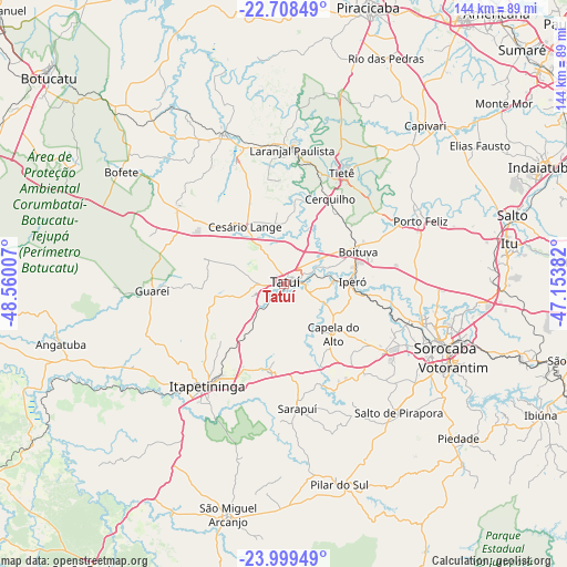
Tatuí GPS coordinates[2]
23° 21' 20.016" South, 47° 51' 24.984" West
| Map corner | latitude | longitude |
|---|---|---|
| Upper-left | -22.70849°, | -48.56007° |
| Center: | -23.35556°, | -47.85694° |
| Lower-right: | -23.99949°, | -47.15382° |
| Map W x H: | 143.5×143.5 km | = 89.2×89.2mi |
| max Lat: | 2.81972° ⇑81.5% North |
| Tatuí: | -23.35556° |
| min Lat: | ⇓18.5% South -33.69111° |
| min Long | Tatuí | max Long |
| -72.89583° | -47.85694° | -32.41083° |
| W 36.1%⇐ | ⇒63.9% E |
Elevation
Elevation of Tatuí is 642 m = 2106 ft, and this is 261.1 m = 857 ft above average elevation for this country.
| Max E: |
1603 m = 5259 ft | 23.8% |
| Tatuí | 642 m 2106 ft | |
| Avg. | 380.9 m = 1250 ft | |
Min E: |
0 m = 0 ft | 76.2% |
See also: Tatuí elevation on elevation.city.
Geographical zone
Tatuí is located in South Torrid zone (between Equator and Tropic of Capricorn). Distance of this Southern Tropic circle is 9 km =5.6 mi to South.| Distance of | km | miles | from Tatuí |
|---|---|---|---|
| Equator | 2596.9 | 1613.6 | to North |
| Tropic Capricorn | 9 | 5.6 | to South |
| Antarctic Circle | 4804.3 | 2985.3 | to South |
| South Pole | 7410.2 | 4604.5 | to South |


Nearby cities:
15 places around Tatuí: (largest is in red/bold)
• Araçoiaba da Serra
29.8 km =18.5 mi,  123°
123°
• Boituva
20.5 km =12.7 mi,  66°
66°
• Capela do Alto
17.9 km =11.1 mi,  135°
135°
• Cerquilho
24.1 km =15 mi,  28°
28°
• Conchas
41 km =25.5 mi,  337°
337°
• Iperó
17.2 km =10.7 mi,  88°
88°
• Itapetininga
33 km =20.5 mi,  217°
217°
• Laranjal Paulista
34.1 km =21.2 mi,  3°
3°
• Pilar do Sul
52.8 km =32.8 mi,  164°
164°
• Porangaba
33.9 km =21.1 mi,  306°
306°
• Porto Feliz
37.4 km =23.2 mi, 65°
• Salto de Pirapora
43.6 km =27.1 mi, 138°
• Sorocaba
43.8 km =27.2 mi,  111°
111°
• Tietê
31.7 km =19.7 mi, 27°
• Votorantim
47.7 km =29.6 mi, 116°
Sources, notices
• [Note1] Compared only with cities in Brazil existing in our database
• [Src1] Map data: © OpenStreetMap contributors (CC-BY-SA)
• [Src2] Other city data from geonames.org with taken over terms of usage.
• [Src3] Geographical zone / Annual Mean Temperature by Robert A. Rohde @ Wikipedia
