Capela do Alto geodata
Capela do Alto (São Paulo) is a populated place; located in Brazil in America/Sao_Paulo (GMT-3) time zone. With population of 11,991 people, there are 1477 cities with bigger population in this country. Compared to other cities in Brazil, 82.4% of cities are located further ↑North; 63.2% of cities are located further →East and 74.5% of cities have lower elevation than Capela do Alto. Note1


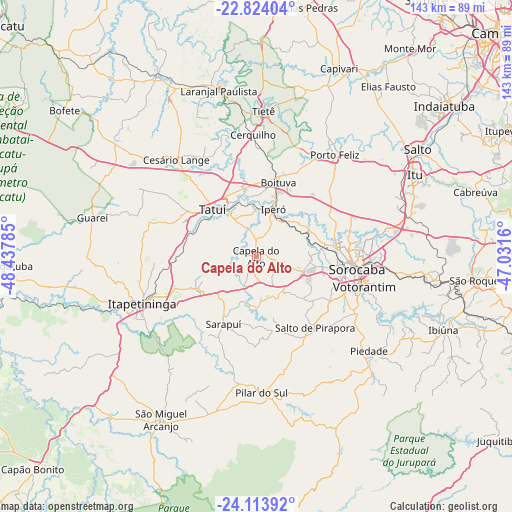
Capela do Alto GPS coordinates[2]
23° 28' 14.016" South, 47° 44' 4.992" West
| Map corner | latitude | longitude |
|---|---|---|
| Upper-left | -22.82404°, | -48.43785° |
| Center: | -23.47056°, | -47.73472° |
| Lower-right: | -24.11392°, | -47.0316° |
| Map W x H: | 143.4×143.4 km | = 89.1×89.1mi |
| max Lat: | 2.81972° ⇑82.4% North |
| Capela do Alto: | -23.47056° |
| min Lat: | ⇓17.6% South -33.69111° |
| min Long | Capela do Alto | max Long |
| -72.89583° | -47.73472° | -32.41083° |
| W 36.8%⇐ | ⇒63.2% E |
Elevation
Elevation of Capela do Alto is 621 m = 2037 ft, and this is 240.1 m = 788 ft above average elevation for this country.
| Max E: |
1603 m = 5259 ft | 25.5% |
| Capela do Alto | 621 m 2037 ft | |
| Avg. | 380.9 m = 1250 ft | |
Min E: |
0 m = 0 ft | 74.5% |
See also: Brazil elevation on elevation.city.
Geographical zone
Capela do Alto is located in South temperate zone (between Tropic of Capricorn and the Antarctic Circle). Distance of this Southern Tropic circle is 3.8 km =2.4 mi to North.| Distance of | km | miles | from Capela do Alto |
|---|---|---|---|
| Equator | 2609.7 | 1621.6 | to North |
| Tropic Capricorn | 3.8 | 2.4 | to North |
| Antarctic Circle | 4791.5 | 2977.3 | to South |
| South Pole | 7397.4 | 4596.5 | to South |


Nearby cities:
15 places around Capela do Alto: (largest is in red/bold)
• Araçoiaba da Serra
12.9 km =8 mi,  107°
107°
• Boituva
21.8 km =13.5 mi,  17°
17°
• Cerquilho
34 km =21.1 mi,  358°
358°
• Iperó
14.2 km =8.8 mi, 19°
• Itapetininga
35.1 km =21.8 mi,  247°
247°
• Itu
50 km =31.1 mi,  62°
62°
• Laranjal Paulista
47.9 km =29.8 mi,  347°
347°
• Piedade
41.2 km =25.6 mi,  130°
130°
• Pilar do Sul
38.1 km =23.7 mi,  177°
177°
• Porto Feliz
35.7 km =22.2 mi,  37°
37°
• Salto de Pirapora
25.8 km =16 mi,  140°
140°
• Sorocaba
28.4 km =17.6 mi,  96°
96°
• Tatuí
17.9 km =11.1 mi,  315°
315°
• Tietê
41 km =25.5 mi,  2°
2°
• Votorantim
31.4 km =19.5 mi, 105°
Sources, notices
• [Note1] Compared only with cities in Brazil existing in our database
• [Src1] Map data: © OpenStreetMap contributors (CC-BY-SA)
• [Src2] Other city data from geonames.org with taken over terms of usage.
• [Src3] Geographical zone / Annual Mean Temperature by Robert A. Rohde @ Wikipedia
