Iperó geodata
Iperó (São Paulo) is a populated place; located in Brazil in America/Sao_Paulo (GMT-3) time zone. With population of 17,160 people, there are 1088 cities with bigger population in this country. Compared to other cities in Brazil, 81.4% of cities are located further ↑North; 62.9% of cities are located further →East and 69.5% of cities have lower elevation than Iperó. Note1


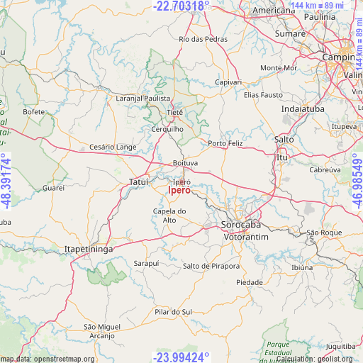
Iperó GPS coordinates[2]
23° 21' 1.008" South, 47° 41' 18.996" West
| Map corner | latitude | longitude |
|---|---|---|
| Upper-left | -22.70318°, | -48.39174° |
| Center: | -23.35028°, | -47.68861° |
| Lower-right: | -23.99424°, | -46.98549° |
| Map W x H: | 143.6×143.6 km | = 89.2×89.2mi |
| max Lat: | 2.81972° ⇑81.4% North |
| Iperó: | -23.35028° |
| min Lat: | ⇓18.6% South -33.69111° |
| min Long | Iperó | max Long |
| -72.89583° | -47.68861° | -32.41083° |
| W 37.1%⇐ | ⇒62.9% E |
Elevation
Elevation of Iperó is 571 m = 1873 ft, and this is 190.1 m = 624 ft above average elevation for this country.
| Max E: |
1603 m = 5259 ft | 30.5% |
| Iperó | 571 m 1873 ft | |
| Avg. | 380.9 m = 1250 ft | |
Min E: |
0 m = 0 ft | 69.5% |
See also: Brazil elevation on elevation.city.
Geographical zone
Iperó is located in South Torrid zone (between Equator and Tropic of Capricorn). Distance of this Southern Tropic circle is 9.6 km =6 mi to South.| Distance of | km | miles | from Iperó |
|---|---|---|---|
| Equator | 2596.3 | 1613.3 | to North |
| Tropic Capricorn | 9.6 | 6 | to South |
| Antarctic Circle | 4804.9 | 2985.6 | to South |
| South Pole | 7410.8 | 4604.9 | to South |


Nearby cities:
15 places around Iperó: (largest is in red/bold)
• Araçoiaba da Serra
18.8 km =11.7 mi,  156°
156°
• Boituva
7.6 km =4.7 mi,  12°
12°
• Capela do Alto
14.2 km =8.8 mi,  199°
199°
• Capivari
43.6 km =27.1 mi,  25°
25°
• Cerquilho
21.4 km =13.3 mi,  344°
344°
• Itapetininga
45.8 km =28.5 mi,  234°
234°
• Itu
40.9 km =25.4 mi,  76°
76°
• Laranjal Paulista
36.7 km =22.8 mi, 335°
• Porto Feliz
22.6 km =14 mi,  48°
48°
• Salto
44.3 km =27.5 mi,  67°
67°
• Salto de Pirapora
35.2 km =21.9 mi, 160°
• Sorocaba
28.9 km =18 mi,  125°
125°
• Tatuí
17.2 km =10.7 mi,  268°
268°
• Tietê
27.7 km =17.2 mi,  354°
354°
• Votorantim
33.6 km =20.9 mi, 130°
Sources, notices
• [Note1] Compared only with cities in Brazil existing in our database
• [Src1] Map data: © OpenStreetMap contributors (CC-BY-SA)
• [Src2] Other city data from geonames.org with taken over terms of usage.
• [Src3] Geographical zone / Annual Mean Temperature by Robert A. Rohde @ Wikipedia
