Porteirinha geodata
Porteirinha (Minas Gerais) is a populated place; located in Brazil in America/Sao_Paulo (GMT-3) time zone. With population of 14,144 people, there are 1281 cities with bigger population in this country. Compared to other cities in Brazil, 54.3% of cities are located further ↓South; 60.1% of cities are located further ←West and 69.5% of cities have lower elevation than Porteirinha. Note1


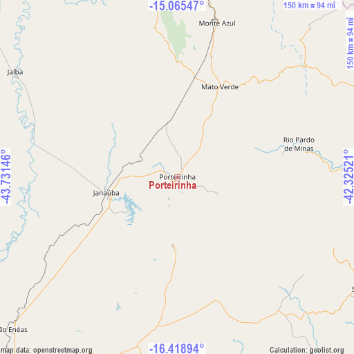
Porteirinha GPS coordinates[2]
15° 44' 35.988" South, 43° 1' 41.988" West
| Map corner | latitude | longitude |
|---|---|---|
| Upper-left | -15.06547°, | -43.73146° |
| Center: | -15.74333°, | -43.02833° |
| Lower-right: | -16.41894°, | -42.32521° |
| Map W x H: | 150.5×150.5 km | = 93.5×93.5mi |
| max Lat: | 2.81972° ⇑45.7% North |
| Porteirinha: | -15.74333° |
| min Lat: | ⇓54.3% South -33.69111° |
| min Long | Porteirinha | max Long |
| -72.89583° | -43.02833° | -32.41083° |
| W 60.1%⇐ | ⇒39.9% E |
Elevation
Elevation of Porteirinha is 570 m = 1870 ft, and this is 189.1 m = 620 ft above average elevation for this country.
| Max E: |
1603 m = 5259 ft | 30.5% |
| Porteirinha | 570 m 1870 ft | |
| Avg. | 380.9 m = 1250 ft | |
Min E: |
0 m = 0 ft | 69.5% |
See also: Brazil elevation on elevation.city.
Geographical zone
Porteirinha is located in South Torrid zone (between Equator and Tropic of Capricorn). Distance of this Southern Tropic circle is 855.4 km =531.5 mi to South.| Distance of | km | miles | from Porteirinha |
|---|---|---|---|
| Equator | 1750.5 | 1087.7 | to North |
| Tropic Capricorn | 855.4 | 531.5 | to South |
| Antarctic Circle | 5650.7 | 3511.2 | to South |
| South Pole | 8256.6 | 5130.4 | to South |


Nearby cities:
15 places around Porteirinha: (largest is in red/bold)
• Barreiro do Jaíba
62 km =38.5 mi,  283°
283°
• Espinosa
93.6 km =58.2 mi,  13°
13°
• Francisco Sá
95.1 km =59.1 mi,  211°
211°
• Itacarambi
134.5 km =83.6 mi,  302°
302°
• Janaúba
30.7 km =19.1 mi,  257°
257°
• Mato Verde
42.2 km =26.2 mi,  24°
24°
• Mirabela
134.5 km =83.6 mi,  244°
244°
• Monte Azul
67.5 km =41.9 mi, 14°
• Montes Claros
141.7 km =88 mi,  218°
218°
• Rio Pardo de Minas
54.4 km =33.8 mi,  74°
74°
• Salinas
92.1 km =57.2 mi,  121°
121°
• São João da Ponte
106.8 km =66.4 mi, 258°
• São João do Paraíso
118.7 km =73.8 mi, 66°
• Taiobeiras
85.4 km =53.1 mi,  94°
94°
• Varzelândia
107 km =66.5 mi,  272°
272°
Sources, notices
• [Note1] Compared only with cities in Brazil existing in our database
• [Src1] Map data: © OpenStreetMap contributors (CC-BY-SA)
• [Src2] Other city data from geonames.org with taken over terms of usage.
• [Src3] Geographical zone / Annual Mean Temperature by Robert A. Rohde @ Wikipedia
