Monte Azul geodata
Monte Azul (Minas Gerais) is a populated place; located in Brazil in America/Sao_Paulo (GMT-3) time zone. With population of 11,221 people, there are 1544 cities with bigger population in this country. Compared to other cities in Brazil, 55.8% of cities are located further ↓South; 61.1% of cities are located further ←West and 71.1% of cities have lower elevation than Monte Azul. Note1


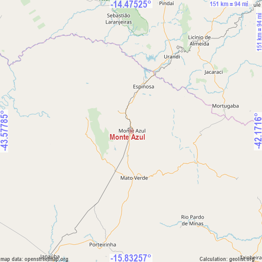
Monte Azul GPS coordinates[2]
15° 9' 18" South, 42° 52' 28.992" West
| Map corner | latitude | longitude |
|---|---|---|
| Upper-left | -14.47525°, | -43.57785° |
| Center: | -15.155°, | -42.87472° |
| Lower-right: | -15.83257°, | -42.1716° |
| Map W x H: | 150.9×150.9 km | = 93.8×93.8mi |
| max Lat: | 2.81972° ⇑44.2% North |
| Monte Azul: | -15.155° |
| min Lat: | ⇓55.8% South -33.69111° |
| min Long | Monte Azul | max Long |
| -72.89583° | -42.87472° | -32.41083° |
| W 61.1%⇐ | ⇒38.9% E |
Elevation
Elevation of Monte Azul is 584 m = 1916 ft, and this is 203.1 m = 666 ft above average elevation for this country.
| Max E: |
1603 m = 5259 ft | 28.9% |
| Monte Azul | 584 m 1916 ft | |
| Avg. | 380.9 m = 1250 ft | |
Min E: |
0 m = 0 ft | 71.1% |
See also: Brazil elevation on elevation.city.
Geographical zone
Monte Azul is located in South Torrid zone (between Equator and Tropic of Capricorn). Distance of this Southern Tropic circle is 920.8 km =572.2 mi to South.| Distance of | km | miles | from Monte Azul |
|---|---|---|---|
| Equator | 1685.1 | 1047.1 | to North |
| Tropic Capricorn | 920.8 | 572.2 | to South |
| Antarctic Circle | 5716.1 | 3551.8 | to South |
| South Pole | 8322 | 5171 | to South |


Nearby cities:
15 places around Monte Azul: (largest is in red/bold)
• Barreiro do Jaíba
92.4 km =57.4 mi,  236°
236°
• Caculé
100.8 km =62.6 mi,  44°
44°
• Caetité
128.1 km =79.6 mi,  19°
19°
• Espinosa
26.1 km =16.2 mi,  13°
13°
• Guanambi
104.1 km =64.7 mi, 5°
• Itacarambi
130.8 km =81.3 mi,  272°
272°
• Janaúba
85.7 km =53.3 mi,  212°
212°
• Manga
122 km =75.8 mi,  291°
291°
• Mato Verde
26.9 km =16.7 mi,  178°
178°
• Palmas de Monte Alto
103.4 km =64.2 mi,  342°
342°
• Porteirinha
67.5 km =41.9 mi,  194°
194°
• Rio Pardo de Minas
62 km =38.5 mi,  144°
144°
• Salinas
129.1 km =80.2 mi,  151°
151°
• São João do Paraíso
94 km =58.4 mi,  100°
100°
• Taiobeiras
100 km =62.1 mi, 136°
Sources, notices
• [Note1] Compared only with cities in Brazil existing in our database
• [Src1] Map data: © OpenStreetMap contributors (CC-BY-SA)
• [Src2] Other city data from geonames.org with taken over terms of usage.
• [Src3] Geographical zone / Annual Mean Temperature by Robert A. Rohde @ Wikipedia
