Mato Verde geodata
Mato Verde (Minas Gerais) is a populated place; located in Brazil in America/Sao_Paulo (GMT-3) time zone. With population of 7,783 people, there are 1783 cities with bigger population in this country. Compared to other cities in Brazil, 55.2% of cities are located further ↓South; 61.2% of cities are located further ←West and 66.8% of cities have lower elevation than Mato Verde. Note1


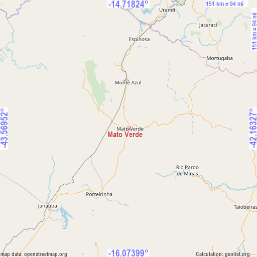
Mato Verde GPS coordinates[2]
15° 23' 49.992" South, 42° 51' 59.004" West
| Map corner | latitude | longitude |
|---|---|---|
| Upper-left | -14.71824°, | -43.56952° |
| Center: | -15.39722°, | -42.86639° |
| Lower-right: | -16.07399°, | -42.16327° |
| Map W x H: | 150.7×150.7 km | = 93.6×93.6mi |
| max Lat: | 2.81972° ⇑44.8% North |
| Mato Verde: | -15.39722° |
| min Lat: | ⇓55.2% South -33.69111° |
| min Long | Mato Verde | max Long |
| -72.89583° | -42.86639° | -32.41083° |
| W 61.2%⇐ | ⇒38.8% E |
Elevation
Elevation of Mato Verde is 543 m = 1781 ft, and this is 162.1 m = 532 ft above average elevation for this country.
| Max E: |
1603 m = 5259 ft | 33.2% |
| Mato Verde | 543 m 1781 ft | |
| Avg. | 380.9 m = 1250 ft | |
Min E: |
0 m = 0 ft | 66.8% |
See also: Brazil elevation on elevation.city.
Geographical zone
Mato Verde is located in South Torrid zone (between Equator and Tropic of Capricorn). Distance of this Southern Tropic circle is 893.9 km =555.4 mi to South.| Distance of | km | miles | from Mato Verde |
|---|---|---|---|
| Equator | 1712 | 1063.8 | to North |
| Tropic Capricorn | 893.9 | 555.4 | to South |
| Antarctic Circle | 5689.2 | 3535.1 | to South |
| South Pole | 8295.1 | 5154.3 | to South |


Nearby cities:
15 places around Mato Verde: (largest is in red/bold)
• Barreiro do Jaíba
81.4 km =50.6 mi,  252°
252°
• Caculé
121.1 km =75.2 mi,  34°
34°
• Espinosa
52.6 km =32.7 mi,  5°
5°
• Guanambi
130.8 km =81.3 mi,  4°
4°
• Itacarambi
135.5 km =84.2 mi,  284°
284°
• Janaúba
65.4 km =40.6 mi,  226°
226°
• Manga
134.8 km =83.8 mi,  301°
301°
• Monte Azul
26.9 km =16.7 mi,  358°
358°
• Palmas de Monte Alto
129.6 km =80.5 mi,  345°
345°
• Porteirinha
42.2 km =26.2 mi,  204°
204°
• Rio Pardo de Minas
42.2 km =26.2 mi,  124°
124°
• Salinas
105.8 km =65.7 mi,  144°
144°
• São João do Paraíso
91.8 km =57 mi,  84°
84°
• Taiobeiras
81.8 km =50.8 mi, 123°
• Varzelândia
128.9 km =80.1 mi, 254°
Sources, notices
• [Note1] Compared only with cities in Brazil existing in our database
• [Src1] Map data: © OpenStreetMap contributors (CC-BY-SA)
• [Src2] Other city data from geonames.org with taken over terms of usage.
• [Src3] Geographical zone / Annual Mean Temperature by Robert A. Rohde @ Wikipedia
