Espinosa geodata
Espinosa (Minas Gerais) is a populated place; located in Brazil in America/Sao_Paulo (GMT-3) time zone. With population of 17,548 people, there are 1060 cities with bigger population in this country. Compared to other cities in Brazil, 56.2% of cities are located further ↓South; 61.6% of cities are located further ←West and 69.1% of cities have lower elevation than Espinosa. Note1


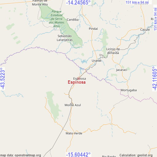
Espinosa GPS coordinates[2]
14° 55' 33.996" South, 42° 49' 9.012" West
| Map corner | latitude | longitude |
|---|---|---|
| Upper-left | -14.24565°, | -43.5223° |
| Center: | -14.92611°, | -42.81917° |
| Lower-right: | -15.60442°, | -42.11605° |
| Map W x H: | 151.1×151.1 km | = 93.9×93.9mi |
| max Lat: | 2.81972° ⇑43.8% North |
| Espinosa: | -14.92611° |
| min Lat: | ⇓56.2% South -33.69111° |
| min Long | Espinosa | max Long |
| -72.89583° | -42.81917° | -32.41083° |
| W 61.6%⇐ | ⇒38.4% E |
Elevation
Elevation of Espinosa is 567 m = 1860 ft, and this is 186.1 m = 611 ft above average elevation for this country.
| Max E: |
1603 m = 5259 ft | 30.9% |
| Espinosa | 567 m 1860 ft | |
| Avg. | 380.9 m = 1250 ft | |
Min E: |
0 m = 0 ft | 69.1% |
See also: Brazil elevation on elevation.city.
Geographical zone
Espinosa is located in South Torrid zone (between Equator and Tropic of Capricorn). Distance of this Southern Tropic circle is 946.3 km =588 mi to South.| Distance of | km | miles | from Espinosa |
|---|---|---|---|
| Equator | 1659.6 | 1031.2 | to North |
| Tropic Capricorn | 946.3 | 588 | to South |
| Antarctic Circle | 5741.5 | 3567.6 | to South |
| South Pole | 8347.4 | 5186.8 | to South |


Nearby cities:
15 places around Espinosa: (largest is in red/bold)
• Barreiro do Jaíba
112.9 km =70.2 mi,  227°
227°
• Caculé
79.6 km =49.5 mi,  53°
53°
• Caetité
102.2 km =63.5 mi,  21°
21°
• Carinhanha
123 km =76.4 mi,  304°
304°
• Guanambi
78.2 km =48.6 mi,  2°
2°
• Janaúba
110.7 km =68.8 mi,  208°
208°
• Manga
121.1 km =75.2 mi,  278°
278°
• Mato Verde
52.6 km =32.7 mi,  185°
185°
• Monte Azul
26.1 km =16.2 mi, 193°
• Palmas de Monte Alto
82 km =51 mi,  333°
333°
• Porteirinha
93.6 km =58.2 mi, 193°
• Rio Pardo de Minas
81.7 km =50.8 mi,  158°
158°
• Santana
120.9 km =75.1 mi,  65°
65°
• São João do Paraíso
96.5 km =60 mi,  116°
116°
• Taiobeiras
116.4 km =72.3 mi,  147°
147°
Sources, notices
• [Note1] Compared only with cities in Brazil existing in our database
• [Src1] Map data: © OpenStreetMap contributors (CC-BY-SA)
• [Src2] Other city data from geonames.org with taken over terms of usage.
• [Src3] Geographical zone / Annual Mean Temperature by Robert A. Rohde @ Wikipedia
