Janaúba geodata
Janaúba (Minas Gerais) is a populated place; located in Brazil in America/Sao_Paulo (GMT-3) time zone. With population of 56,572 people, there are 387 cities with bigger population in this country. Compared to other cities in Brazil, 54.1% of cities are located further ↓South; 59% of cities are located further ←West and 66.4% of cities have lower elevation than Janaúba. Note1


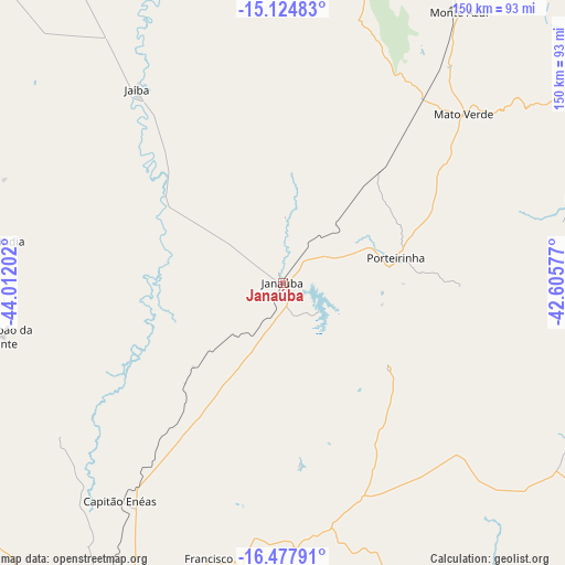
Janaúba GPS coordinates[2]
15° 48' 9" South, 43° 18' 32.004" West
| Map corner | latitude | longitude |
|---|---|---|
| Upper-left | -15.12483°, | -44.01202° |
| Center: | -15.8025°, | -43.30889° |
| Lower-right: | -16.47791°, | -42.60577° |
| Map W x H: | 150.4×150.5 km | = 93.5×93.5mi |
| max Lat: | 2.81972° ⇑45.9% North |
| Janaúba: | -15.8025° |
| min Lat: | ⇓54.1% South -33.69111° |
| min Long | Janaúba | max Long |
| -72.89583° | -43.30889° | -32.41083° |
| W 59%⇐ | ⇒41% E |
Elevation
Elevation of Janaúba is 539 m = 1768 ft, and this is 158.1 m = 519 ft above average elevation for this country.
| Max E: |
1603 m = 5259 ft | 33.6% |
| Janaúba | 539 m 1768 ft | |
| Avg. | 380.9 m = 1250 ft | |
Min E: |
0 m = 0 ft | 66.4% |
See also: Janaúba elevation on elevation.city.
Geographical zone
Janaúba is located in South Torrid zone (between Equator and Tropic of Capricorn). Distance of this Southern Tropic circle is 848.8 km =527.4 mi to South.| Distance of | km | miles | from Janaúba |
|---|---|---|---|
| Equator | 1757.1 | 1091.8 | to North |
| Tropic Capricorn | 848.8 | 527.4 | to South |
| Antarctic Circle | 5644.1 | 3507.1 | to South |
| South Pole | 8250 | 5126.3 | to South |


Nearby cities:
15 places around Janaúba: (largest is in red/bold)
• Barreiro do Jaíba
36.8 km =22.9 mi,  304°
304°
• Espinosa
110.7 km =68.8 mi,  28°
28°
• Francisco Sá
77.3 km =48 mi,  194°
194°
• Itacarambi
114.5 km =71.1 mi,  312°
312°
• Januária
117.8 km =73.2 mi,  287°
287°
• Mato Verde
65.4 km =40.6 mi,  46°
46°
• Mirabela
104.8 km =65.1 mi,  240°
240°
• Monte Azul
85.7 km =53.3 mi, 32°
• Montes Claros
119.3 km =74.1 mi,  209°
209°
• Porteirinha
30.7 km =19.1 mi,  77°
77°
• Rio Pardo de Minas
85.1 km =52.9 mi, 75°
• Salinas
116.3 km =72.3 mi,  110°
110°
• São João da Ponte
76.1 km =47.3 mi,  259°
259°
• Taiobeiras
115.1 km =71.5 mi,  90°
90°
• Varzelândia
77.7 km =48.3 mi,  278°
278°
Sources, notices
• [Note1] Compared only with cities in Brazil existing in our database
• [Src1] Map data: © OpenStreetMap contributors (CC-BY-SA)
• [Src2] Other city data from geonames.org with taken over terms of usage.
• [Src3] Geographical zone / Annual Mean Temperature by Robert A. Rohde @ Wikipedia
