Palmas geodata
Palmas (Paraná) is a populated place; located in Brazil in America/Sao_Paulo (GMT-3) time zone. With population of 39,150 people, there are 535 cities with bigger population in this country. Compared to other cities in Brazil, 90.5% of cities are located further ↑North; 87.8% of cities are located further →East and 99.3% of cities have lower elevation than Palmas. Note1


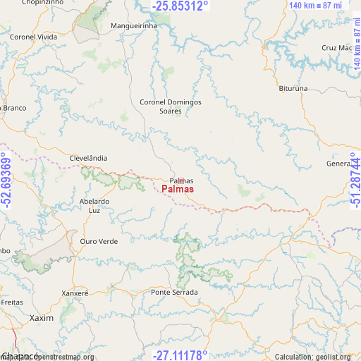
Palmas GPS coordinates[2]
26° 29' 3.012" South, 51° 59' 26.016" West
| Map corner | latitude | longitude |
|---|---|---|
| Upper-left | -25.85312°, | -52.69369° |
| Center: | -26.48417°, | -51.99056° |
| Lower-right: | -27.11178°, | -51.28744° |
| Map W x H: | 139.9×140 km | = 86.9×87mi |
| max Lat: | 2.81972° ⇑90.5% North |
| Palmas: | -26.48417° |
| min Lat: | ⇓9.5% South -33.69111° |
| min Long | Palmas | max Long |
| -72.89583° | -51.99056° | -32.41083° |
| W 12.2%⇐ | ⇒87.8% E |
Elevation
Elevation of Palmas is 1075 m = 3527 ft, and this is 694.1 m = 2277 ft above average elevation for this country.
| Max E: |
1603 m = 5259 ft | 0.7% |
| Palmas | 1075 m 3527 ft | |
| Avg. | 380.9 m = 1250 ft | |
Min E: |
0 m = 0 ft | 99.3% |
See also: Brazil elevation on elevation.city.
Geographical zone
Palmas is located in South temperate zone (between Tropic of Capricorn and the Antarctic Circle). Distance of this Southern Tropic circle is 338.8 km =210.5 mi to North.| Distance of | km | miles | from Palmas |
|---|---|---|---|
| Equator | 2944.8 | 1829.8 | to North |
| Tropic Capricorn | 338.8 | 210.5 | to North |
| Antarctic Circle | 4456.4 | 2769.1 | to South |
| South Pole | 7062.3 | 4388.3 | to South |


Nearby cities:
15 places around Palmas: (largest is in red/bold)
• Capinzal
102.7 km =63.8 mi,  158°
158°
• Caçador
102.2 km =63.5 mi,  108°
108°
• Chapecó
92.3 km =57.4 mi,  222°
222°
• Chopinzinho
87.8 km =54.6 mi,  322°
322°
• Clevelândia
48.8 km =30.3 mi,  281°
281°
• Concórdia
83.5 km =51.9 mi,  182°
182°
• Coronel Vivida
80.4 km =50 mi,  314°
314°
• Joaçaba
91 km =56.5 mi,  148°
148°
• Pato Branco
73.5 km =45.7 mi,  292°
292°
• Pinhão
93.7 km =58.2 mi,  20°
20°
• Porto União
94.9 km =59 mi,  73°
73°
• São Lourenço do Oeste
86.8 km =53.9 mi, 279°
• União da Vitória
94.4 km =58.7 mi, 72°
• Videira
101.7 km =63.2 mi,  124°
124°
• Xanxerê
60 km =37.3 mi, 223°
Sources, notices
• [Note1] Compared only with cities in Brazil existing in our database
• [Src1] Map data: © OpenStreetMap contributors (CC-BY-SA)
• [Src2] Other city data from geonames.org with taken over terms of usage.
• [Src3] Geographical zone / Annual Mean Temperature by Robert A. Rohde @ Wikipedia
