Caçador geodata
Caçador (Santa Catarina) is a populated place; located in Brazil in America/Sao_Paulo (GMT-3) time zone. With population of 63,726 people, there are 348 cities with bigger population in this country. Compared to other cities in Brazil, 90.7% of cities are located further ↑North; 82.4% of cities are located further →East and 96% of cities have lower elevation than Caçador. Note1


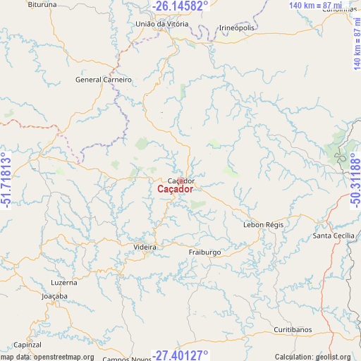
Caçador GPS coordinates[2]
26° 46' 31.008" South, 51° 0' 54" West
| Map corner | latitude | longitude |
|---|---|---|
| Upper-left | -26.14582°, | -51.71813° |
| Center: | -26.77528°, | -51.015° |
| Lower-right: | -27.40127°, | -50.31188° |
| Map W x H: | 139.6×139.6 km | = 86.7×86.7mi |
| max Lat: | 2.81972° ⇑90.7% North |
| Caçador: | -26.77528° |
| min Lat: | ⇓9.3% South -33.69111° |
| min Long | Caçador | max Long |
| -72.89583° | -51.015° | -32.41083° |
| W 17.6%⇐ | ⇒82.4% E |
Elevation
Elevation of Caçador is 916 m = 3005 ft, and this is 535.1 m = 1756 ft above average elevation for this country.
| Max E: |
1603 m = 5259 ft | 4% |
| Caçador | 916 m 3005 ft | |
| Avg. | 380.9 m = 1250 ft | |
Min E: |
0 m = 0 ft | 96% |
See also: Caçador elevation on elevation.city.
Geographical zone
Caçador is located in South temperate zone (between Tropic of Capricorn and the Antarctic Circle). Distance of this Southern Tropic circle is 371.2 km =230.7 mi to North.| Distance of | km | miles | from Caçador |
|---|---|---|---|
| Equator | 2977.1 | 1849.9 | to North |
| Tropic Capricorn | 371.2 | 230.7 | to North |
| Antarctic Circle | 4424 | 2748.9 | to South |
| South Pole | 7029.9 | 4368.2 | to South |


Nearby cities:
15 places around Caçador: (largest is in red/bold)
• Campos Novos
72.7 km =45.2 mi,  196°
196°
• Canoinhas
91.1 km =56.6 mi,  43°
43°
• Capinzal
86.5 km =53.7 mi,  223°
223°
• Celso Ramos
100.7 km =62.6 mi, 198°
• Concórdia
112.6 km =70 mi,  243°
243°
• Correia Pinto
110.8 km =68.8 mi,  144°
144°
• Curitibanos
70.7 km =43.9 mi, 142°
• Joaçaba
66 km =41 mi,  227°
227°
• Otacílio Costa
118.3 km =73.5 mi,  131°
131°
• Palmas
102.2 km =63.5 mi,  288°
288°
• Porto União
60.1 km =37.3 mi,  353°
353°
• Santa Cecília
61.9 km =38.5 mi,  109°
109°
• Três Barras
101.4 km =63 mi, 42°
• União da Vitória
61 km =37.9 mi, 353°
• Videira
29.2 km =18.1 mi,  207°
207°
Sources, notices
• [Note1] Compared only with cities in Brazil existing in our database
• [Src1] Map data: © OpenStreetMap contributors (CC-BY-SA)
• [Src2] Other city data from geonames.org with taken over terms of usage.
• [Src3] Geographical zone / Annual Mean Temperature by Robert A. Rohde @ Wikipedia
