Joaçaba geodata
Joaçaba (Santa Catarina) is a populated place; located in Brazil in America/Sao_Paulo (GMT-3) time zone. With population of 23,516 people, there are 819 cities with bigger population in this country. Compared to other cities in Brazil, 91.6% of cities are located further ↑North; 85.6% of cities are located further →East and 67.4% of cities have lower elevation than Joaçaba. Note1


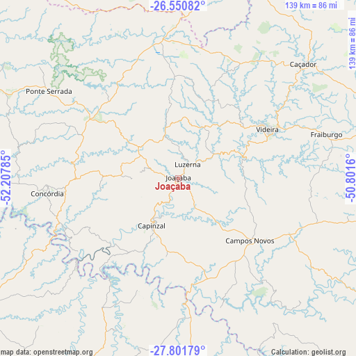
Joaçaba GPS coordinates[2]
27° 10' 41.016" South, 51° 30' 16.992" West
| Map corner | latitude | longitude |
|---|---|---|
| Upper-left | -26.55082°, | -52.20785° |
| Center: | -27.17806°, | -51.50472° |
| Lower-right: | -27.80179°, | -50.8016° |
| Map W x H: | 139.1×139.1 km | = 86.4×86.4mi |
| max Lat: | 2.81972° ⇑91.6% North |
| Joaçaba: | -27.17806° |
| min Lat: | ⇓8.4% South -33.69111° |
| min Long | Joaçaba | max Long |
| -72.89583° | -51.50472° | -32.41083° |
| W 14.4%⇐ | ⇒85.6% E |
Elevation
Elevation of Joaçaba is 551 m = 1808 ft, and this is 170.1 m = 558 ft above average elevation for this country.
| Max E: |
1603 m = 5259 ft | 32.6% |
| Joaçaba | 551 m 1808 ft | |
| Avg. | 380.9 m = 1250 ft | |
Min E: |
0 m = 0 ft | 67.4% |
See also: Brazil elevation on elevation.city.
Geographical zone
Joaçaba is located in South temperate zone (between Tropic of Capricorn and the Antarctic Circle). Distance of this Southern Tropic circle is 416 km =258.5 mi to North.| Distance of | km | miles | from Joaçaba |
|---|---|---|---|
| Equator | 3021.9 | 1877.7 | to North |
| Tropic Capricorn | 416 | 258.5 | to North |
| Antarctic Circle | 4379.3 | 2721.2 | to South |
| South Pole | 6985.1 | 4340.3 | to South |


Nearby cities:
15 places around Joaçaba: (largest is in red/bold)
• Campos Novos
37.2 km =23.1 mi,  131°
131°
• Capinzal
21.2 km =13.2 mi,  209°
209°
• Caçador
66 km =41 mi,  47°
47°
• Celso Ramos
53.4 km =33.2 mi,  161°
161°
• Chapecó
110.6 km =68.7 mi,  274°
274°
• Concórdia
52.1 km =32.4 mi,  263°
263°
• Curitibanos
91.7 km =57 mi,  97°
97°
• Erechim
91.5 km =56.9 mi,  236°
236°
• Palmas
91 km =56.5 mi,  328°
328°
• Porto União
112.8 km =70.1 mi,  22°
22°
• Sananduva
90.8 km =56.4 mi,  199°
199°
• Santa Cecília
109.4 km =68 mi,  77°
77°
• Tapejara
110.9 km =68.9 mi, 206°
• Videira
39.7 km =24.7 mi,  61°
61°
• Xanxerê
95.2 km =59.2 mi,  290°
290°
Sources, notices
• [Note1] Compared only with cities in Brazil existing in our database
• [Src1] Map data: © OpenStreetMap contributors (CC-BY-SA)
• [Src2] Other city data from geonames.org with taken over terms of usage.
• [Src3] Geographical zone / Annual Mean Temperature by Robert A. Rohde @ Wikipedia
