Ipuã geodata
Ipuã (São Paulo) is a populated place; located in Brazil in America/Sao_Paulo (GMT-3) time zone. With population of 12,370 people, there are 1441 cities with bigger population in this country. Compared to other cities in Brazil, 59.7% of cities are located further ↑North; 64.6% of cities are located further →East and 67.4% of cities have lower elevation than Ipuã. Note1


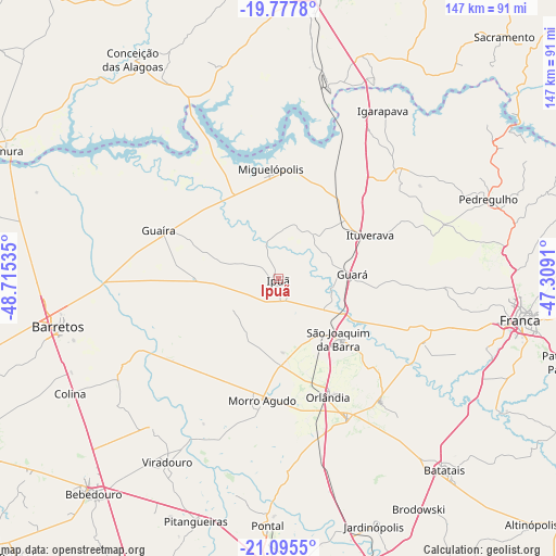
Ipuã GPS coordinates[2]
20° 26' 17.016" South, 48° 0' 43.992" West
| Map corner | latitude | longitude |
|---|---|---|
| Upper-left | -19.7778°, | -48.71535° |
| Center: | -20.43806°, | -48.01222° |
| Lower-right: | -21.0955°, | -47.3091° |
| Map W x H: | 146.5×146.5 km | = 91×91mi |
| max Lat: | 2.81972° ⇑59.7% North |
| Ipuã: | -20.43806° |
| min Lat: | ⇓40.3% South -33.69111° |
| min Long | Ipuã | max Long |
| -72.89583° | -48.01222° | -32.41083° |
| W 35.4%⇐ | ⇒64.6% E |
Elevation
Elevation of Ipuã is 551 m = 1808 ft, and this is 170.1 m = 558 ft above average elevation for this country.
| Max E: |
1603 m = 5259 ft | 32.6% |
| Ipuã | 551 m 1808 ft | |
| Avg. | 380.9 m = 1250 ft | |
Min E: |
0 m = 0 ft | 67.4% |
See also: Brazil elevation on elevation.city.
Geographical zone
Ipuã is located in South Torrid zone (between Equator and Tropic of Capricorn). Distance of this Southern Tropic circle is 333.4 km =207.2 mi to South.| Distance of | km | miles | from Ipuã |
|---|---|---|---|
| Equator | 2272.5 | 1412.1 | to North |
| Tropic Capricorn | 333.4 | 207.2 | to South |
| Antarctic Circle | 5128.7 | 3186.8 | to South |
| South Pole | 7734.6 | 4806.1 | to South |


Nearby cities:
15 places around Ipuã: (largest is in red/bold)
• Barretos
59.4 km =36.9 mi,  257°
257°
• Batatais
67.2 km =41.8 mi,  138°
138°
• Franca
64.7 km =40.2 mi,  99°
99°
• Guará
19.6 km =12.2 mi,  86°
86°
• Guaíra
33.8 km =21 mi,  293°
293°
• Igarapava
52.4 km =32.6 mi,  31°
31°
• Ituverava
26.5 km =16.5 mi,  65°
65°
• Miguelópolis
28.8 km =17.9 mi,  355°
355°
• Morro Agudo
33 km =20.5 mi,  188°
188°
• Nuporanga
42.4 km =26.3 mi, 140°
• Orlândia
34 km =21.1 mi,  157°
157°
• Pedregulho
59.4 km =36.9 mi, 70°
• Pontal
65 km =40.4 mi,  182°
182°
• São Joaquim da Barra
22.9 km =14.2 mi,  134°
134°
• Viradouro
56.7 km =35.2 mi,  211°
211°
Sources, notices
• [Note1] Compared only with cities in Brazil existing in our database
• [Src1] Map data: © OpenStreetMap contributors (CC-BY-SA)
• [Src2] Other city data from geonames.org with taken over terms of usage.
• [Src3] Geographical zone / Annual Mean Temperature by Robert A. Rohde @ Wikipedia
