Ituverava geodata
Ituverava (São Paulo) is a populated place; located in Brazil in America/Sao_Paulo (GMT-3) time zone. With population of 36,997 people, there are 559 cities with bigger population in this country. Compared to other cities in Brazil, 58.9% of cities are located further ↑North; 63.5% of cities are located further →East and 73.5% of cities have lower elevation than Ituverava. Note1


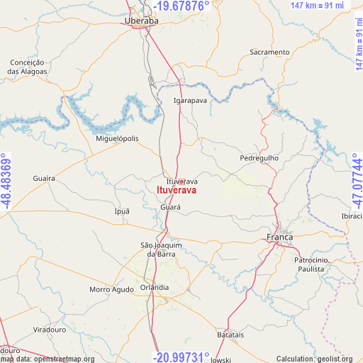
Ituverava GPS coordinates[2]
20° 20' 21.984" South, 47° 46' 50.016" West
| Map corner | latitude | longitude |
|---|---|---|
| Upper-left | -19.67876°, | -48.48369° |
| Center: | -20.33944°, | -47.78056° |
| Lower-right: | -20.99731°, | -47.07744° |
| Map W x H: | 146.6×146.6 km | = 91.1×91.1mi |
| max Lat: | 2.81972° ⇑58.9% North |
| Ituverava: | -20.33944° |
| min Lat: | ⇓41.1% South -33.69111° |
| min Long | Ituverava | max Long |
| -72.89583° | -47.78056° | -32.41083° |
| W 36.5%⇐ | ⇒63.5% E |
Elevation
Elevation of Ituverava is 607 m = 1991 ft, and this is 226.1 m = 742 ft above average elevation for this country.
| Max E: |
1603 m = 5259 ft | 26.5% |
| Ituverava | 607 m 1991 ft | |
| Avg. | 380.9 m = 1250 ft | |
Min E: |
0 m = 0 ft | 73.5% |
See also: Brazil elevation on elevation.city.
Geographical zone
Ituverava is located in South Torrid zone (between Equator and Tropic of Capricorn). Distance of this Southern Tropic circle is 344.4 km =214 mi to South.| Distance of | km | miles | from Ituverava |
|---|---|---|---|
| Equator | 2261.5 | 1405.2 | to North |
| Tropic Capricorn | 344.4 | 214 | to South |
| Antarctic Circle | 5139.6 | 3193.6 | to South |
| South Pole | 7745.5 | 4812.8 | to South |


Nearby cities:
15 places around Ituverava: (largest is in red/bold)
• Batatais
64.6 km =40.1 mi,  161°
161°
• Brodósqui
73.6 km =45.7 mi,  170°
170°
• Franca
45.3 km =28.1 mi,  119°
119°
• Guará
10.9 km =6.8 mi,  204°
204°
• Guaíra
55.3 km =34.4 mi,  272°
272°
• Igarapava
33.7 km =20.9 mi,  5°
5°
• Ipuã
26.5 km =16.5 mi,  245°
245°
• Miguelópolis
31.7 km =19.7 mi,  304°
304°
• Morro Agudo
52.3 km =32.5 mi,  213°
213°
• Nuporanga
43.6 km =27.1 mi,  176°
176°
• Orlândia
43.8 km =27.2 mi,  194°
194°
• Pedregulho
33 km =20.5 mi,  73°
73°
• Sacramento
63.6 km =39.5 mi,  33°
33°
• São Joaquim da Barra
28 km =17.4 mi, 196°
• Uberaba
67.6 km =42 mi,  346°
346°
Sources, notices
• [Note1] Compared only with cities in Brazil existing in our database
• [Src1] Map data: © OpenStreetMap contributors (CC-BY-SA)
• [Src2] Other city data from geonames.org with taken over terms of usage.
• [Src3] Geographical zone / Annual Mean Temperature by Robert A. Rohde @ Wikipedia
