Inhambupe geodata
Inhambupe (Bahia) is a populated place; located in Brazil in America/Bahia (GMT-3) time zone. With population of 14,735 people, there are 1230 cities with bigger population in this country. Compared to other cities in Brazil, 62.8% of cities are located further ↓South; 83.2% of cities are located further ←West and 64.8% of cities have higher elevation than Inhambupe. Note1


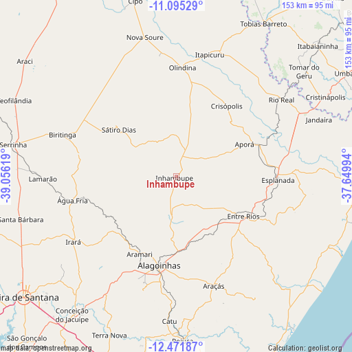
Inhambupe GPS coordinates[2]
11° 47' 3.984" South, 38° 21' 11.016" West
| Map corner | latitude | longitude |
|---|---|---|
| Upper-left | -11.09529°, | -39.05619° |
| Center: | -11.78444°, | -38.35306° |
| Lower-right: | -12.47187°, | -37.64994° |
| Map W x H: | 153.1×153.1 km | = 95.1×95.1mi |
| max Lat: | 2.81972° ⇑37.2% North |
| Inhambupe: | -11.78444° |
| min Lat: | ⇓62.8% South -33.69111° |
| min Long | Inhambupe | max Long |
| -72.89583° | -38.35306° | -32.41083° |
| W 83.2%⇐ | ⇒16.8% E |
Elevation
Elevation of Inhambupe is 169 m = 554 ft, and this is 211.9 m = 695 ft below average elevation for this country.
| Max E: |
1603 m = 5259 ft | 64.8% |
| Avg. | 380.9 m = 1250 ft | |
| Inhambupe | 169 m = 554 ft | |
Min E: |
0 m = 0 ft | 35.2% |
See also: Brazil elevation on elevation.city.
Geographical zone
Inhambupe is located in South Torrid zone (between Equator and Tropic of Capricorn). Distance of this Southern Tropic circle is 1295.6 km =805 mi to South.| Distance of | km | miles | from Inhambupe |
|---|---|---|---|
| Equator | 1310.3 | 814.2 | to North |
| Tropic Capricorn | 1295.6 | 805 | to South |
| Antarctic Circle | 6090.9 | 3784.7 | to South |
| South Pole | 8696.8 | 5403.9 | to South |


Nearby cities:
15 places around Inhambupe: (largest is in red/bold)
• Acajutiba
39 km =24.2 mi,  69°
69°
• Alagoinhas
39.7 km =24.7 mi,  190°
190°
• Catu
63.3 km =39.3 mi,  182°
182°
• Conceição do Jacuípe
74.3 km =46.2 mi,  217°
217°
• Coração de Maria
66 km =41 mi, 220°
• Cristinápolis
73.6 km =45.7 mi,  62°
62°
• Entre Rios
34.1 km =21.2 mi,  120°
120°
• Esplanada
44.4 km =27.6 mi,  91°
91°
• Irará
53.8 km =33.4 mi,  236°
236°
• Itapicuru
53.6 km =33.3 mi,  14°
14°
• Nova Soure
62.9 km =39.1 mi,  346°
346°
• Olindina
46.5 km =28.9 mi,  2°
2°
• Rio Real
56.6 km =35.2 mi,  53°
53°
• Serrinha
72.5 km =45 mi,  280°
280°
• Tomar do Geru
72.2 km =44.9 mi, 50°
Sources, notices
• [Note1] Compared only with cities in Brazil existing in our database
• [Src1] Map data: © OpenStreetMap contributors (CC-BY-SA)
• [Src2] Other city data from geonames.org with taken over terms of usage.
• [Src3] Geographical zone / Annual Mean Temperature by Robert A. Rohde @ Wikipedia
