Carlos Barbosa geodata
Carlos Barbosa (Rio Grande do Sul) is a populated place; located in Brazil in America/Sao_Paulo (GMT-3) time zone. With population of 19,105 people, there are 976 cities with bigger population in this country. Compared to other cities in Brazil, 96.5% of cities are located further ↑North; 85.5% of cities are located further →East and 79.4% of cities have lower elevation than Carlos Barbosa. Note1


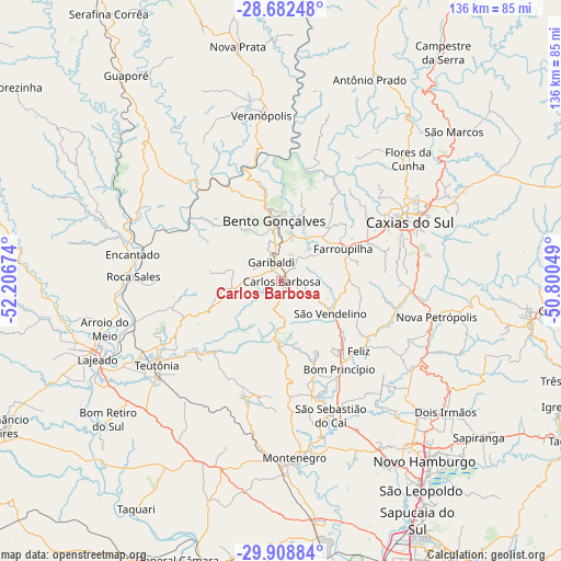
Carlos Barbosa GPS coordinates[2]
29° 17' 51" South, 51° 30' 12.996" West
| Map corner | latitude | longitude |
|---|---|---|
| Upper-left | -28.68248°, | -52.20674° |
| Center: | -29.2975°, | -51.50361° |
| Lower-right: | -29.90884°, | -50.80049° |
| Map W x H: | 136.4×136.4 km | = 84.8×84.8mi |
| max Lat: | 2.81972° ⇑96.5% North |
| Carlos Barbosa: | -29.2975° |
| min Lat: | ⇓3.5% South -33.69111° |
| min Long | Carlos Barbosa | max Long |
| -72.89583° | -51.50361° | -32.41083° |
| W 14.5%⇐ | ⇒85.5% E |
Elevation
Elevation of Carlos Barbosa is 680 m = 2231 ft, and this is 299.1 m = 981 ft above average elevation for this country.
| Max E: |
1603 m = 5259 ft | 20.6% |
| Carlos Barbosa | 680 m 2231 ft | |
| Avg. | 380.9 m = 1250 ft | |
Min E: |
0 m = 0 ft | 79.4% |
See also: Brazil elevation on elevation.city.
Geographical zone
Carlos Barbosa is located in South temperate zone (between Tropic of Capricorn and the Antarctic Circle). Distance of this Southern Tropic circle is 651.7 km =404.9 mi to North.| Distance of | km | miles | from Carlos Barbosa |
|---|---|---|---|
| Equator | 3257.6 | 2024.2 | to North |
| Tropic Capricorn | 651.7 | 404.9 | to North |
| Antarctic Circle | 4143.6 | 2574.7 | to South |
| South Pole | 6749.5 | 4193.9 | to South |


Nearby cities:
15 places around Carlos Barbosa: (largest is in red/bold)
• Arroio do Meio
44.3 km =27.5 mi,  254°
254°
• Bento Gonçalves
14.1 km =8.8 mi,  353°
353°
• Caxias do Sul
34.6 km =21.5 mi,  65°
65°
• Encantado
36.2 km =22.5 mi,  280°
280°
• Estância Velha
50.4 km =31.3 mi,  140°
140°
• Farroupilha
17.1 km =10.6 mi,  61°
61°
• Flores da Cunha
43.2 km =26.8 mi,  46°
46°
• Garibaldi
5.4 km =3.4 mi,  327°
327°
• Ivoti
46.6 km =29 mi,  134°
134°
• Lajeado
48.2 km =30 mi, 246°
• Montenegro
43.7 km =27.2 mi,  174°
174°
• Nova Petrópolis
38.7 km =24 mi,  103°
103°
• São Sebastião do Caí
34.5 km =21.4 mi,  158°
158°
• Teutônia
33.8 km =21 mi,  240°
240°
• Veranópolis
40.4 km =25.1 mi, 353°
Sources, notices
• [Note1] Compared only with cities in Brazil existing in our database
• [Src1] Map data: © OpenStreetMap contributors (CC-BY-SA)
• [Src2] Other city data from geonames.org with taken over terms of usage.
• [Src3] Geographical zone / Annual Mean Temperature by Robert A. Rohde @ Wikipedia
