Miraí geodata
Miraí (Minas Gerais) is a populated place; located in Brazil in America/Sao_Paulo (GMT-3) time zone. With population of 8,499 people, there are 1752 cities with bigger population in this country. Compared to other cities in Brazil, 64.5% of cities are located further ↑North; 62.9% of cities are located further ←West and 50.9% of cities have higher elevation than Miraí. Note1


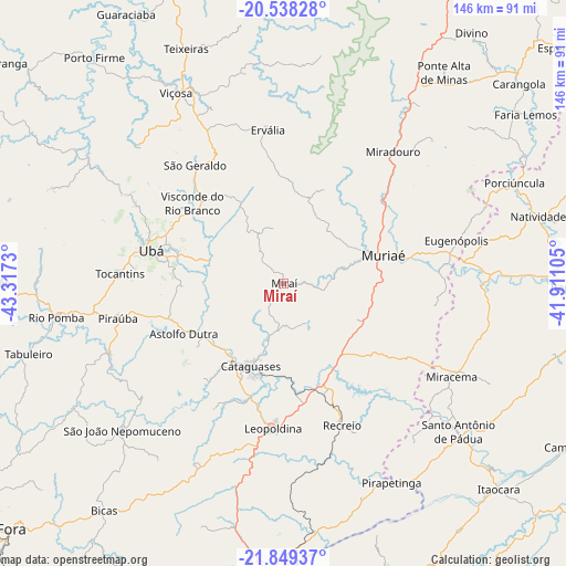
Miraí GPS coordinates[2]
21° 11' 43.008" South, 42° 36' 51.012" West
| Map corner | latitude | longitude |
|---|---|---|
| Upper-left | -20.53828°, | -43.3173° |
| Center: | -21.19528°, | -42.61417° |
| Lower-right: | -21.84937°, | -41.91105° |
| Map W x H: | 145.8×145.8 km | = 90.6×90.6mi |
| max Lat: | 2.81972° ⇑64.5% North |
| Miraí: | -21.19528° |
| min Lat: | ⇓35.5% South -33.69111° |
| min Long | Miraí | max Long |
| -72.89583° | -42.61417° | -32.41083° |
| W 62.9%⇐ | ⇒37.1% E |
Elevation
Elevation of Miraí is 343 m = 1125 ft, and this is 37.9 m = 124 ft below average elevation for this country.
| Max E: |
1603 m = 5259 ft | 50.9% |
| Avg. | 380.9 m = 1250 ft | |
| Miraí | 343 m = 1125 ft | |
Min E: |
0 m = 0 ft | 49.1% |
See also: Brazil elevation on elevation.city.
Geographical zone
Miraí is located in South Torrid zone (between Equator and Tropic of Capricorn). Distance of this Southern Tropic circle is 249.2 km =154.8 mi to South.| Distance of | km | miles | from Miraí |
|---|---|---|---|
| Equator | 2356.7 | 1464.4 | to North |
| Tropic Capricorn | 249.2 | 154.8 | to South |
| Antarctic Circle | 5044.5 | 3134.5 | to South |
| South Pole | 7650.4 | 4753.7 | to South |


Nearby cities:
15 places around Miraí: (largest is in red/bold)
• Astolfo Dutra
29 km =18 mi,  242°
242°
• Cataguases
23.2 km =14.4 mi,  201°
201°
• Leopoldina
37.6 km =23.4 mi,  184°
184°
• Miracema
49.5 km =30.8 mi,  119°
119°
• Muriaé
26.7 km =16.6 mi,  74°
74°
• Porciúncula
64.9 km =40.3 mi, 66°
• Recreio
39.6 km =24.6 mi,  157°
157°
• Rio Novo
61.6 km =38.3 mi, 239°
• Rio Pomba
59.2 km =36.8 mi,  261°
261°
• Santo Antônio de Pádua
59 km =36.7 mi,  130°
130°
• São João Nepomuceno
56.2 km =34.9 mi,  226°
226°
• Tocantins
41.9 km =26 mi,  273°
273°
• Ubá
35.1 km =21.8 mi,  283°
283°
• Visconde do Rio Branco
31.2 km =19.4 mi,  311°
311°
• Viçosa
56.4 km =35 mi,  330°
330°
Sources, notices
• [Note1] Compared only with cities in Brazil existing in our database
• [Src1] Map data: © OpenStreetMap contributors (CC-BY-SA)
• [Src2] Other city data from geonames.org with taken over terms of usage.
• [Src3] Geographical zone / Annual Mean Temperature by Robert A. Rohde @ Wikipedia
