Astolfo Dutra geodata
Astolfo Dutra (Minas Gerais) is a populated place; located in Brazil in America/Sao_Paulo (GMT-3) time zone. With population of 10,999 people, there are 1569 cities with bigger population in this country. Compared to other cities in Brazil, 65.5% of cities are located further ↑North; 61.3% of cities are located further ←West and 55.8% of cities have higher elevation than Astolfo Dutra. Note1


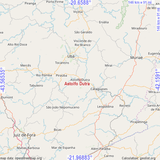
Astolfo Dutra GPS coordinates[2]
21° 18' 55.008" South, 42° 51' 43.992" West
| Map corner | latitude | longitude |
|---|---|---|
| Upper-left | -20.6588°, | -43.56535° |
| Center: | -21.31528°, | -42.86222° |
| Lower-right: | -21.96883°, | -42.1591° |
| Map W x H: | 145.7×145.7 km | = 90.5×90.5mi |
| max Lat: | 2.81972° ⇑65.5% North |
| Astolfo Dutra: | -21.31528° |
| min Lat: | ⇓34.5% South -33.69111° |
| min Long | Astolfo Dutra | max Long |
| -72.89583° | -42.86222° | -32.41083° |
| W 61.3%⇐ | ⇒38.7% E |
Elevation
Elevation of Astolfo Dutra is 256 m = 840 ft, and this is 124.9 m = 410 ft below average elevation for this country.
| Max E: |
1603 m = 5259 ft | 55.8% |
| Avg. | 380.9 m = 1250 ft | |
| Astolfo Dutra | 256 m = 840 ft | |
Min E: |
0 m = 0 ft | 44.2% |
See also: Brazil elevation on elevation.city.
Geographical zone
Astolfo Dutra is located in South Torrid zone (between Equator and Tropic of Capricorn). Distance of this Southern Tropic circle is 235.9 km =146.6 mi to South.| Distance of | km | miles | from Astolfo Dutra |
|---|---|---|---|
| Equator | 2370 | 1472.6 | to North |
| Tropic Capricorn | 235.9 | 146.6 | to South |
| Antarctic Circle | 5031.1 | 3126.2 | to South |
| South Pole | 7637 | 4745.4 | to South |


Nearby cities:
15 places around Astolfo Dutra: (largest is in red/bold)
• Além Paraíba
65.7 km =40.8 mi,  165°
165°
• Bicas
49.9 km =31 mi,  204°
204°
• Cataguases
19 km =11.8 mi,  115°
115°
• Leopoldina
33.1 km =20.6 mi,  136°
136°
• Mar de Espanha
63.2 km =39.3 mi,  193°
193°
• Miraí
29 km =18 mi,  62°
62°
• Muriaé
55.3 km =34.4 mi,  68°
68°
• Recreio
46.9 km =29.1 mi, 119°
• Rio Novo
32.7 km =20.3 mi,  236°
236°
• Rio Pomba
33.1 km =20.6 mi,  277°
277°
• São João Nepomuceno
29.3 km =18.2 mi,  211°
211°
• Tocantins
22.4 km =13.9 mi,  314°
314°
• Ubá
23.3 km =14.5 mi,  338°
338°
• Visconde do Rio Branco
34 km =21.1 mi,  3°
3°
• Viçosa
62.5 km =38.8 mi,  358°
358°
Sources, notices
• [Note1] Compared only with cities in Brazil existing in our database
• [Src1] Map data: © OpenStreetMap contributors (CC-BY-SA)
• [Src2] Other city data from geonames.org with taken over terms of usage.
• [Src3] Geographical zone / Annual Mean Temperature by Robert A. Rohde @ Wikipedia
