Maracaí geodata
Maracaí (São Paulo) is a populated place; located in Brazil in America/Sao_Paulo (GMT-3) time zone. With population of 11,959 people, there are 1479 cities with bigger population in this country. Compared to other cities in Brazil, 74.8% of cities are located further ↑North; 81.3% of cities are located further →East and 52.8% of cities have lower elevation than Maracaí. Note1


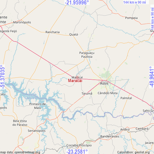
Maracaí GPS coordinates[2]
22° 36' 38.016" South, 50° 40' 1.992" West
| Map corner | latitude | longitude |
|---|---|---|
| Upper-left | -21.95996°, | -51.37035° |
| Center: | -22.61056°, | -50.66722° |
| Lower-right: | -23.2581°, | -49.9641° |
| Map W x H: | 144.3×144.3 km | = 89.7×89.7mi |
| max Lat: | 2.81972° ⇑74.8% North |
| Maracaí: | -22.61056° |
| min Lat: | ⇓25.2% South -33.69111° |
| min Long | Maracaí | max Long |
| -72.89583° | -50.66722° | -32.41083° |
| W 18.7%⇐ | ⇒81.3% E |
Elevation
Elevation of Maracaí is 392 m = 1286 ft, and this is 11.1 m = 36 ft above average elevation for this country.
| Max E: |
1603 m = 5259 ft | 47.2% |
| Maracaí | 392 m 1286 ft | |
| Avg. | 380.9 m = 1250 ft | |
Min E: |
0 m = 0 ft | 52.8% |
See also: Brazil elevation on elevation.city.
Geographical zone
Maracaí is located in South Torrid zone (between Equator and Tropic of Capricorn). Distance of this Southern Tropic circle is 91.9 km =57.1 mi to South.| Distance of | km | miles | from Maracaí |
|---|---|---|---|
| Equator | 2514.1 | 1562.2 | to North |
| Tropic Capricorn | 91.9 | 57.1 | to South |
| Antarctic Circle | 4887.1 | 3036.7 | to South |
| South Pole | 7493 | 4655.9 | to South |


Nearby cities:
15 places around Maracaí: (largest is in red/bold)
• Assis
26.8 km =16.7 mi,  102°
102°
• Bandeirantes
63.5 km =39.5 mi,  151°
151°
• Bela Vista do Paraíso
68.7 km =42.7 mi,  231°
231°
• Cornélio Procópio
63.5 km =39.5 mi,  178°
178°
• Cândido Mota
32.5 km =20.2 mi,  117°
117°
• Martinópolis
73.2 km =45.5 mi,  314°
314°
• Palmital
50.2 km =31.2 mi,  113°
113°
• Paraguaçu Paulista
23.9 km =14.9 mi,  23°
23°
• Pompéia
75.6 km =47 mi,  42°
42°
• Porecatu
74.8 km =46.5 mi,  257°
257°
• Quatá
40.5 km =25.2 mi,  355°
355°
• Rancharia
48.3 km =30 mi,  331°
331°
• Sertanópolis
62.6 km =38.9 mi,  217°
217°
• Tarumã
17.7 km =11 mi, 148°
• Tupã
76.8 km =47.7 mi,  11°
11°
Sources, notices
• [Note1] Compared only with cities in Brazil existing in our database
• [Src1] Map data: © OpenStreetMap contributors (CC-BY-SA)
• [Src2] Other city data from geonames.org with taken over terms of usage.
• [Src3] Geographical zone / Annual Mean Temperature by Robert A. Rohde @ Wikipedia
