Bela Vista do Paraíso geodata
Bela Vista do Paraíso (Paraná) is a populated place; located in Brazil in America/Sao_Paulo (GMT-3) time zone. With population of 14,332 people, there are 1264 cities with bigger population in this country. Compared to other cities in Brazil, 78.5% of cities are located further ↑North; 84% of cities are located further →East and 75.6% of cities have lower elevation than Bela Vista do Paraíso. Note1


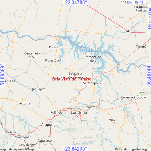
Bela Vista do Paraíso GPS coordinates[2]
22° 59' 48.012" South, 51° 11' 26.016" West
| Map corner | latitude | longitude |
|---|---|---|
| Upper-left | -22.34788°, | -51.89369° |
| Center: | -22.99667°, | -51.19056° |
| Lower-right: | -23.64235°, | -50.48744° |
| Map W x H: | 143.9×143.9 km | = 89.4×89.4mi |
| max Lat: | 2.81972° ⇑78.5% North |
| Bela Vista do Paraíso: | -22.99667° |
| min Lat: | ⇓21.5% South -33.69111° |
| min Long | Bela Vista do P | max Long |
| -72.89583° | -51.19056° | -32.41083° |
| W 16%⇐ | ⇒84% E |
Elevation
Elevation of Bela Vista do Paraíso is 633 m = 2077 ft, and this is 252.1 m = 827 ft above average elevation for this country.
| Max E: |
1603 m = 5259 ft | 24.4% |
| Bela Vista do Paraíso | 633 m 2077 ft | |
| Avg. | 380.9 m = 1250 ft | |
Min E: |
0 m = 0 ft | 75.6% |
See also: Brazil elevation on elevation.city.
Geographical zone
Bela Vista do Paraíso is located in South Torrid zone (between Equator and Tropic of Capricorn). Distance of this Southern Tropic circle is 48.9 km =30.4 mi to South.| Distance of | km | miles | from Bela Vista do Paraíso |
|---|---|---|---|
| Equator | 2557 | 1588.8 | to North |
| Tropic Capricorn | 48.9 | 30.4 | to South |
| Antarctic Circle | 4844.2 | 3010 | to South |
| South Pole | 7450.1 | 4629.3 | to South |


Nearby cities:
15 places around Bela Vista do Paraíso: (largest is in red/bold)
• Apucarana
67.5 km =41.9 mi,  204°
204°
• Arapongas
52.7 km =32.7 mi,  206°
206°
• Assaí
55 km =34.2 mi,  139°
139°
• Astorga
55.2 km =34.3 mi,  241°
241°
• Cambé
32.3 km =20.1 mi, 196°
• Centenário do Sul
45.8 km =28.5 mi,  295°
295°
• Cornélio Procópio
59.3 km =36.8 mi,  110°
110°
• Florestópolis
25 km =15.5 mi,  306°
306°
• Ibiporã
33.6 km =20.9 mi,  154°
154°
• Jataizinho
35.8 km =22.2 mi, 143°
• Londrina
35 km =21.7 mi,  175°
175°
• Maracaí
68.7 km =42.7 mi,  51°
51°
• Porecatu
33 km =20.5 mi,  324°
324°
• Rolândia
39.3 km =24.4 mi, 207°
• Sertanópolis
17.2 km =10.7 mi, 113°
Sources, notices
• [Note1] Compared only with cities in Brazil existing in our database
• [Src1] Map data: © OpenStreetMap contributors (CC-BY-SA)
• [Src2] Other city data from geonames.org with taken over terms of usage.
• [Src3] Geographical zone / Annual Mean Temperature by Robert A. Rohde @ Wikipedia
