Porecatu geodata
Porecatu (Paraná) is a populated place; located in Brazil in America/Sao_Paulo (GMT-3) time zone. With population of 11,390 people, there are 1531 cities with bigger population in this country. Compared to other cities in Brazil, 76.3% of cities are located further ↑North; 84.9% of cities are located further →East and 53.6% of cities have lower elevation than Porecatu. Note1


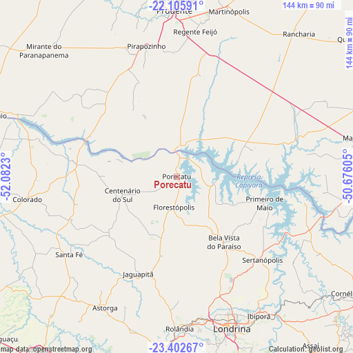
Porecatu GPS coordinates[2]
22° 45' 20.988" South, 51° 22' 45.012" West
| Map corner | latitude | longitude |
|---|---|---|
| Upper-left | -22.10591°, | -52.0823° |
| Center: | -22.75583°, | -51.37917° |
| Lower-right: | -23.40267°, | -50.67605° |
| Map W x H: | 144.2×144.2 km | = 89.6×89.6mi |
| max Lat: | 2.81972° ⇑76.3% North |
| Porecatu: | -22.75583° |
| min Lat: | ⇓23.7% South -33.69111° |
| min Long | Porecatu | max Long |
| -72.89583° | -51.37917° | -32.41083° |
| W 15.1%⇐ | ⇒84.9% E |
Elevation
Elevation of Porecatu is 404 m = 1325 ft, and this is 23.1 m = 76 ft above average elevation for this country.
| Max E: |
1603 m = 5259 ft | 46.4% |
| Porecatu | 404 m 1325 ft | |
| Avg. | 380.9 m = 1250 ft | |
Min E: |
0 m = 0 ft | 53.6% |
See also: Brazil elevation on elevation.city.
Geographical zone
Porecatu is located in South Torrid zone (between Equator and Tropic of Capricorn). Distance of this Southern Tropic circle is 75.7 km =47 mi to South.| Distance of | km | miles | from Porecatu |
|---|---|---|---|
| Equator | 2530.2 | 1572.2 | to North |
| Tropic Capricorn | 75.7 | 47 | to South |
| Antarctic Circle | 4871 | 3026.7 | to South |
| South Pole | 7476.9 | 4645.9 | to South |


Nearby cities:
15 places around Porecatu: (largest is in red/bold)
• Astorga
60.6 km =37.7 mi,  208°
208°
• Bela Vista do Paraíso
33 km =20.5 mi,  144°
144°
• Cambé
58.7 km =36.5 mi,  169°
169°
• Centenário do Sul
23.3 km =14.5 mi,  251°
251°
• Colorado
61.5 km =38.2 mi,  261°
261°
• Florestópolis
12 km =7.5 mi,  183°
183°
• Ibiporã
66.4 km =41.3 mi,  149°
149°
• Jataizinho
68.8 km =42.8 mi, 143°
• Londrina
65.5 km =40.7 mi,  160°
160°
• Martinópolis
71.1 km =44.2 mi,  17°
17°
• Pirapozinho
54.9 km =34.1 mi,  346°
346°
• Presidente Prudente
70.1 km =43.6 mi,  359°
359°
• Regente Feijó
59.9 km =37.2 mi,  7°
7°
• Rolândia
61.6 km =38.3 mi, 179°
• Sertanópolis
48.6 km =30.2 mi,  133°
133°
Sources, notices
• [Note1] Compared only with cities in Brazil existing in our database
• [Src1] Map data: © OpenStreetMap contributors (CC-BY-SA)
• [Src2] Other city data from geonames.org with taken over terms of usage.
• [Src3] Geographical zone / Annual Mean Temperature by Robert A. Rohde @ Wikipedia
