Tupã geodata
Tupã (São Paulo) is a populated place; located in Brazil in America/Sao_Paulo (GMT-3) time zone. With population of 62,035 people, there are 361 cities with bigger population in this country. Compared to other cities in Brazil, 69.6% of cities are located further ↑North; 80.5% of cities are located further →East and 65.3% of cities have lower elevation than Tupã. Note1


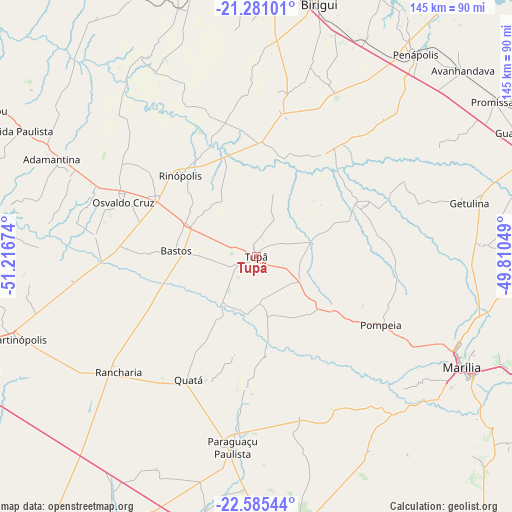
Tupã GPS coordinates[2]
21° 56' 4.992" South, 50° 30' 48.996" West
| Map corner | latitude | longitude |
|---|---|---|
| Upper-left | -21.28101°, | -51.21674° |
| Center: | -21.93472°, | -50.51361° |
| Lower-right: | -22.58544°, | -49.81049° |
| Map W x H: | 145×145 km | = 90.1×90.1mi |
| max Lat: | 2.81972° ⇑69.6% North |
| Tupã: | -21.93472° |
| min Lat: | ⇓30.4% South -33.69111° |
| min Long | Tupã | max Long |
| -72.89583° | -50.51361° | -32.41083° |
| W 19.5%⇐ | ⇒80.5% E |
Elevation
Elevation of Tupã is 528 m = 1732 ft, and this is 147.1 m = 483 ft above average elevation for this country.
| Max E: |
1603 m = 5259 ft | 34.7% |
| Tupã | 528 m 1732 ft | |
| Avg. | 380.9 m = 1250 ft | |
Min E: |
0 m = 0 ft | 65.3% |
See also: Tupã elevation on elevation.city.
Geographical zone
Tupã is located in South Torrid zone (between Equator and Tropic of Capricorn). Distance of this Southern Tropic circle is 167 km =103.8 mi to South.| Distance of | km | miles | from Tupã |
|---|---|---|---|
| Equator | 2438.9 | 1515.5 | to North |
| Tropic Capricorn | 167 | 103.8 | to South |
| Antarctic Circle | 4962.3 | 3083.4 | to South |
| South Pole | 7568.1 | 4702.6 | to South |


Nearby cities:
15 places around Tupã: (largest is in red/bold)
• Adamantina
64 km =39.8 mi,  295°
295°
• Bastos
22.8 km =14.2 mi,  273°
273°
• Birigui
74 km =46 mi,  14°
14°
• Guararapes
76.1 km =47.3 mi,  349°
349°
• Lucélia
57.3 km =35.6 mi,  294°
294°
• Maracaí
76.8 km =47.7 mi,  191°
191°
• Martinópolis
71.7 km =44.6 mi,  250°
250°
• Marília
66.2 km =41.1 mi,  117°
117°
• Osvaldo Cruz
40.7 km =25.3 mi, 292°
• Paraguaçu Paulista
53.5 km =33.2 mi, 186°
• Paulista Flórida
80.1 km =49.8 mi, 297°
• Penápolis
72.9 km =45.3 mi,  38°
38°
• Pompéia
40.2 km =25 mi, 118°
• Quatá
39.6 km =24.6 mi,  208°
208°
• Rancharia
51 km =31.7 mi,  230°
230°
Sources, notices
• [Note1] Compared only with cities in Brazil existing in our database
• [Src1] Map data: © OpenStreetMap contributors (CC-BY-SA)
• [Src2] Other city data from geonames.org with taken over terms of usage.
• [Src3] Geographical zone / Annual Mean Temperature by Robert A. Rohde @ Wikipedia
