Cândido Mota geodata
Cândido Mota (São Paulo) is a populated place; located in Brazil in America/Sao_Paulo (GMT-3) time zone. With population of 28,144 people, there are 704 cities with bigger population in this country. Compared to other cities in Brazil, 76% of cities are located further ↑North; 80% of cities are located further →East and 61% of cities have lower elevation than Cândido Mota. Note1


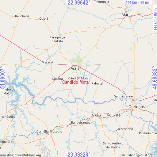
Cândido Mota GPS coordinates[2]
22° 44' 47.004" South, 50° 23' 12.984" West
| Map corner | latitude | longitude |
|---|---|---|
| Upper-left | -22.09642°, | -51.09007° |
| Center: | -22.74639°, | -50.38694° |
| Lower-right: | -23.39328°, | -49.68382° |
| Map W x H: | 144.2×144.2 km | = 89.6×89.6mi |
| max Lat: | 2.81972° ⇑76% North |
| Cândido Mota: | -22.74639° |
| min Lat: | ⇓24% South -33.69111° |
| min Long | Cândido Mota | max Long |
| -72.89583° | -50.38694° | -32.41083° |
| W 20%⇐ | ⇒80% E |
Elevation
Elevation of Cândido Mota is 483 m = 1585 ft, and this is 102.1 m = 335 ft above average elevation for this country.
| Max E: |
1603 m = 5259 ft | 39% |
| Cândido Mota | 483 m 1585 ft | |
| Avg. | 380.9 m = 1250 ft | |
Min E: |
0 m = 0 ft | 61% |
See also: Brazil elevation on elevation.city.
Geographical zone
Cândido Mota is located in South Torrid zone (between Equator and Tropic of Capricorn). Distance of this Southern Tropic circle is 76.8 km =47.7 mi to South.| Distance of | km | miles | from Cândido Mota |
|---|---|---|---|
| Equator | 2529.2 | 1571.6 | to North |
| Tropic Capricorn | 76.8 | 47.7 | to South |
| Antarctic Circle | 4872 | 3027.3 | to South |
| South Pole | 7477.9 | 4646.6 | to South |


Nearby cities:
15 places around Cândido Mota: (largest is in red/bold)
• Assis
9.8 km =6.1 mi,  344°
344°
• Bandeirantes
40.5 km =25.2 mi,  177°
177°
• Cambará
46.3 km =28.8 mi,  136°
136°
• Cornélio Procópio
55.2 km =34.3 mi,  208°
208°
• Jacarezinho
62.8 km =39 mi, 137°
• Maracaí
32.5 km =20.2 mi,  297°
297°
• Marília
74.6 km =46.4 mi,  37°
37°
• Ourinhos
58.9 km =36.6 mi,  116°
116°
• Palmital
18 km =11.2 mi,  105°
105°
• Paraguaçu Paulista
41.9 km =26 mi,  332°
332°
• Pompéia
74.3 km =46.2 mi,  17°
17°
• Quatá
64 km =39.8 mi, 330°
• Santo Antônio da Platina
68.7 km =42.7 mi,  152°
152°
• Sertanópolis
75 km =46.6 mi,  242°
242°
• Tarumã
19.5 km =12.1 mi,  269°
269°
Sources, notices
• [Note1] Compared only with cities in Brazil existing in our database
• [Src1] Map data: © OpenStreetMap contributors (CC-BY-SA)
• [Src2] Other city data from geonames.org with taken over terms of usage.
• [Src3] Geographical zone / Annual Mean Temperature by Robert A. Rohde @ Wikipedia
