Pompéia geodata
Pompéia (São Paulo) is a populated place; located in Brazil in America/Sao_Paulo (GMT-3) time zone. With population of 18,015 people, there are 1044 cities with bigger population in this country. Compared to other cities in Brazil, 70.6% of cities are located further ↑North; 79.1% of cities are located further →East and 72.8% of cities have lower elevation than Pompéia. Note1


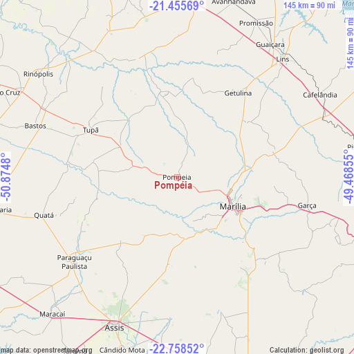
Pompéia GPS coordinates[2]
22° 6' 30.996" South, 50° 10' 18.012" West
| Map corner | latitude | longitude |
|---|---|---|
| Upper-left | -21.45569°, | -50.8748° |
| Center: | -22.10861°, | -50.17167° |
| Lower-right: | -22.75852°, | -49.46855° |
| Map W x H: | 144.9×144.9 km | = 90×90mi |
| max Lat: | 2.81972° ⇑70.6% North |
| Pompéia: | -22.10861° |
| min Lat: | ⇓29.4% South -33.69111° |
| min Long | Pompéia | max Long |
| -72.89583° | -50.17167° | -32.41083° |
| W 20.9%⇐ | ⇒79.1% E |
Elevation
Elevation of Pompéia is 601 m = 1972 ft, and this is 220.1 m = 722 ft above average elevation for this country.
| Max E: |
1603 m = 5259 ft | 27.2% |
| Pompéia | 601 m 1972 ft | |
| Avg. | 380.9 m = 1250 ft | |
Min E: |
0 m = 0 ft | 72.8% |
See also: Brazil elevation on elevation.city.
Geographical zone
Pompéia is located in South Torrid zone (between Equator and Tropic of Capricorn). Distance of this Southern Tropic circle is 147.7 km =91.8 mi to South.| Distance of | km | miles | from Pompéia |
|---|---|---|---|
| Equator | 2458.2 | 1527.5 | to North |
| Tropic Capricorn | 147.7 | 91.8 | to South |
| Antarctic Circle | 4942.9 | 3071.4 | to South |
| South Pole | 7548.8 | 4690.6 | to South |


Nearby cities:
15 places around Pompéia: (largest is in red/bold)
• Assis
66.3 km =41.2 mi,  201°
201°
• Bastos
61.6 km =38.3 mi,  289°
289°
• Cafelândia
67.2 km =41.8 mi,  59°
59°
• Cândido Mota
74.3 km =46.2 mi, 197°
• Garça
54.3 km =33.7 mi,  102°
102°
• Lins
65.2 km =40.5 mi,  42°
42°
• Maracaí
75.6 km =47 mi,  222°
222°
• Marília
26 km =16.2 mi,  116°
116°
• Palmital
75.8 km =47.1 mi,  183°
183°
• Paraguaçu Paulista
53.6 km =33.3 mi,  230°
230°
• Pirajuí
74.6 km =46.4 mi,  80°
80°
• Promissão
71.4 km =44.4 mi,  26°
26°
• Quatá
56.4 km =35 mi,  254°
254°
• Rancharia
75.5 km =46.9 mi,  259°
259°
• Tupã
40.2 km =25 mi,  298°
298°
Sources, notices
• [Note1] Compared only with cities in Brazil existing in our database
• [Src1] Map data: © OpenStreetMap contributors (CC-BY-SA)
• [Src2] Other city data from geonames.org with taken over terms of usage.
• [Src3] Geographical zone / Annual Mean Temperature by Robert A. Rohde @ Wikipedia
