Rio Negro geodata
Rio Negro (Paraná) is a populated place; located in Brazil in America/Sao_Paulo (GMT-3) time zone. With population of 23,006 people, there are 831 cities with bigger population in this country. Compared to other cities in Brazil, 89.7% of cities are located further ↑North; 77.1% of cities are located further →East and 88.9% of cities have lower elevation than Rio Negro. Note1


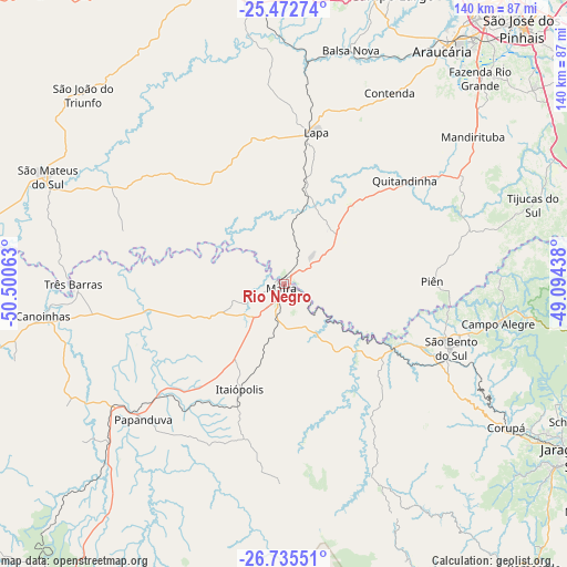
Rio Negro GPS coordinates[2]
26° 6' 20.988" South, 49° 47' 51" West
| Map corner | latitude | longitude |
|---|---|---|
| Upper-left | -25.47274°, | -50.50063° |
| Center: | -26.10583°, | -49.7975° |
| Lower-right: | -26.73551°, | -49.09438° |
| Map W x H: | 140.4×140.4 km | = 87.2×87.2mi |
| max Lat: | 2.81972° ⇑89.7% North |
| Rio Negro: | -26.10583° |
| min Lat: | ⇓10.3% South -33.69111° |
| min Long | Rio Negro | max Long |
| -72.89583° | -49.7975° | -32.41083° |
| W 22.9%⇐ | ⇒77.1% E |
Elevation
Elevation of Rio Negro is 795 m = 2608 ft, and this is 414.1 m = 1359 ft above average elevation for this country.
| Max E: |
1603 m = 5259 ft | 11.1% |
| Rio Negro | 795 m 2608 ft | |
| Avg. | 380.9 m = 1250 ft | |
Min E: |
0 m = 0 ft | 88.9% |
See also: Brazil elevation on elevation.city.
Geographical zone
Rio Negro is located in South temperate zone (between Tropic of Capricorn and the Antarctic Circle). Distance of this Southern Tropic circle is 296.8 km =184.4 mi to North.| Distance of | km | miles | from Rio Negro |
|---|---|---|---|
| Equator | 2902.7 | 1803.7 | to North |
| Tropic Capricorn | 296.8 | 184.4 | to North |
| Antarctic Circle | 4498.5 | 2795.2 | to South |
| South Pole | 7104.4 | 4414.5 | to South |


Nearby cities:
15 places around Rio Negro: (largest is in red/bold)
• Araucária
68.9 km =42.8 mi,  34°
34°
• Campo Largo
76.7 km =47.7 mi,  20°
20°
• Canoinhas
59.7 km =37.1 mi,  262°
262°
• Corupá
65.7 km =40.8 mi,  122°
122°
• Guaramirim
89.1 km =55.4 mi, 117°
• Jaraguá do Sul
84.2 km =52.3 mi, 120°
• Lapa
38.3 km =23.8 mi,  12°
12°
• Mafra
1 km =0.6 mi,  231°
231°
• Palmeira
78.1 km =48.5 mi,  344°
344°
• Rio Negrinho
32.4 km =20.1 mi, 120°
• Schroeder
79.9 km =49.6 mi, 115°
• São Bento do Sul
44.8 km =27.8 mi,  111°
111°
• São José dos Pinhais
87 km =54.1 mi,  42°
42°
• São Mateus do Sul
63.9 km =39.7 mi,  293°
293°
• Três Barras
52.4 km =32.6 mi,  269°
269°
Sources, notices
• [Note1] Compared only with cities in Brazil existing in our database
• [Src1] Map data: © OpenStreetMap contributors (CC-BY-SA)
• [Src2] Other city data from geonames.org with taken over terms of usage.
• [Src3] Geographical zone / Annual Mean Temperature by Robert A. Rohde @ Wikipedia
