Mafra geodata
Mafra (Santa Catarina) is a populated place; located in Brazil in America/Sao_Paulo (GMT-3) time zone. With population of 40,081 people, there are 527 cities with bigger population in this country. Compared to other cities in Brazil, 89.8% of cities are located further ↑North; 77.3% of cities are located further →East and 89.8% of cities have lower elevation than Mafra. Note1


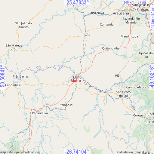
Mafra GPS coordinates[2]
26° 6' 41.004" South, 49° 48' 19.008" West
| Map corner | latitude | longitude |
|---|---|---|
| Upper-left | -25.47833°, | -50.50841° |
| Center: | -26.11139°, | -49.80528° |
| Lower-right: | -26.74104°, | -49.10216° |
| Map W x H: | 140.4×140.4 km | = 87.2×87.2mi |
| max Lat: | 2.81972° ⇑89.8% North |
| Mafra: | -26.11139° |
| min Lat: | ⇓10.2% South -33.69111° |
| min Long | Mafra | max Long |
| -72.89583° | -49.80528° | -32.41083° |
| W 22.7%⇐ | ⇒77.3% E |
Elevation
Elevation of Mafra is 806 m = 2644 ft, and this is 425.1 m = 1395 ft above average elevation for this country.
| Max E: |
1603 m = 5259 ft | 10.2% |
| Mafra | 806 m 2644 ft | |
| Avg. | 380.9 m = 1250 ft | |
Min E: |
0 m = 0 ft | 89.8% |
See also: Mafra elevation on elevation.city.
Geographical zone
Mafra is located in South temperate zone (between Tropic of Capricorn and the Antarctic Circle). Distance of this Southern Tropic circle is 297.4 km =184.8 mi to North.| Distance of | km | miles | from Mafra |
|---|---|---|---|
| Equator | 2903.3 | 1804 | to North |
| Tropic Capricorn | 297.4 | 184.8 | to North |
| Antarctic Circle | 4497.9 | 2794.9 | to South |
| South Pole | 7103.7 | 4414 | to South |


Nearby cities:
15 places around Mafra: (largest is in red/bold)
• Araucária
69.9 km =43.4 mi,  34°
34°
• Campo Largo
77.5 km =48.2 mi,  20°
20°
• Canoinhas
58.8 km =36.5 mi,  262°
262°
• Corupá
66 km =41 mi,  121°
121°
• Guaramirim
89.5 km =55.6 mi, 116°
• Jaraguá do Sul
84.6 km =52.6 mi, 119°
• Lapa
39 km =24.2 mi,  13°
13°
• Palmeira
78.5 km =48.8 mi,  345°
345°
• Rio Negrinho
32.8 km =20.4 mi, 119°
• Rio Negro
1 km =0.6 mi,  51°
51°
• Schroeder
80.3 km =49.9 mi,  114°
114°
• São Bento do Sul
45.3 km =28.1 mi, 109°
• São José dos Pinhais
88 km =54.7 mi,  42°
42°
• São Mateus do Sul
63.5 km =39.5 mi,  294°
294°
• Três Barras
51.6 km =32.1 mi,  270°
270°
Sources, notices
• [Note1] Compared only with cities in Brazil existing in our database
• [Src1] Map data: © OpenStreetMap contributors (CC-BY-SA)
• [Src2] Other city data from geonames.org with taken over terms of usage.
• [Src3] Geographical zone / Annual Mean Temperature by Robert A. Rohde @ Wikipedia
