Januária geodata
Januária (Minas Gerais) is a populated place; located in Brazil in America/Sao_Paulo (GMT-3) time zone. With population of 34,811 people, there are 587 cities with bigger population in this country. Compared to other cities in Brazil, 55% of cities are located further ↓South; 53.9% of cities are located further ←West and 58.5% of cities have lower elevation than Januária. Note1


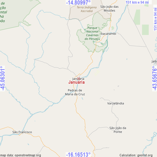
Januária GPS coordinates[2]
15° 29' 19.176" South, 44° 21' 35.568" West
| Map corner | latitude | longitude |
|---|---|---|
| Upper-left | -14.80997°, | -45.06301° |
| Center: | -15.48866°, | -44.35988° |
| Lower-right: | -16.16513°, | -43.65676° |
| Map W x H: | 150.7×150.7 km | = 93.6×93.6mi |
| max Lat: | 2.81972° ⇑45% North |
| Januária: | -15.48866° |
| min Lat: | ⇓55% South -33.69111° |
| min Long | Januária | max Long |
| -72.89583° | -44.35988° | -32.41083° |
| W 53.9%⇐ | ⇒46.1% E |
Elevation
Elevation of Januária is 459 m = 1506 ft, and this is 78.1 m = 256 ft above average elevation for this country.
| Max E: |
1603 m = 5259 ft | 41.5% |
| Januária | 459 m 1506 ft | |
| Avg. | 380.9 m = 1250 ft | |
Min E: |
0 m = 0 ft | 58.5% |
See also: Brazil elevation on elevation.city.
Geographical zone
Januária is located in South Torrid zone (between Equator and Tropic of Capricorn). Distance of this Southern Tropic circle is 883.7 km =549.1 mi to South.| Distance of | km | miles | from Januária |
|---|---|---|---|
| Equator | 1722.2 | 1070.1 | to North |
| Tropic Capricorn | 883.7 | 549.1 | to South |
| Antarctic Circle | 5679 | 3528.8 | to South |
| South Pole | 8284.9 | 5148 | to South |


Nearby cities:
15 places around Januária: (largest is in red/bold)
• Barreiro do Jaíba
83.5 km =51.9 mi,  99°
99°
• Brasília de Minas
80.2 km =49.8 mi,  185°
185°
• Carinhanha
146.3 km =90.9 mi,  25°
25°
• Coração de Jesus
133.1 km =82.7 mi,  180°
180°
• Francisco Sá
144 km =89.5 mi,  139°
139°
• Itacarambi
51.7 km =32.1 mi, 33°
• Janaúba
117.8 km =73.2 mi,  107°
107°
• Manga
93.5 km =58.1 mi, 29°
• Mato Verde
160.4 km =99.7 mi,  86°
86°
• Mirabela
88.6 km =55.1 mi,  166°
166°
• Montes Claros
148.4 km =92.2 mi,  158°
158°
• Porteirinha
145.4 km =90.3 mi, 101°
• São Francisco
74.4 km =46.2 mi,  226°
226°
• São João da Ponte
61.8 km =38.4 mi, 142°
• Varzelândia
42.7 km =26.5 mi,  123°
123°
Sources, notices
• [Note1] Compared only with cities in Brazil existing in our database
• [Src1] Map data: © OpenStreetMap contributors (CC-BY-SA)
• [Src2] Other city data from geonames.org with taken over terms of usage.
• [Src3] Geographical zone / Annual Mean Temperature by Robert A. Rohde @ Wikipedia
