Carinhanha geodata
Carinhanha (Bahia) is a populated place; located in Brazil in America/Bahia (GMT-3) time zone. With population of 11,407 people, there are 1529 cities with bigger population in this country. Compared to other cities in Brazil, 57.6% of cities are located further ↓South; 57.2% of cities are located further ←West and 58% of cities have lower elevation than Carinhanha. Note1


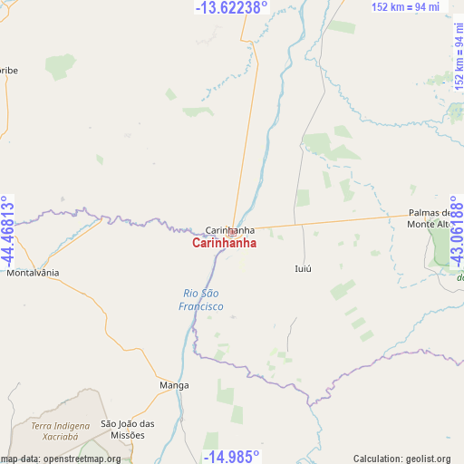
Carinhanha GPS coordinates[2]
14° 18' 16.992" South, 43° 45' 54" West
| Map corner | latitude | longitude |
|---|---|---|
| Upper-left | -13.62238°, | -44.46813° |
| Center: | -14.30472°, | -43.765° |
| Lower-right: | -14.985°, | -43.06188° |
| Map W x H: | 151.5×151.5 km | = 94.1×94.1mi |
| max Lat: | 2.81972° ⇑42.4% North |
| Carinhanha: | -14.30472° |
| min Lat: | ⇓57.6% South -33.69111° |
| min Long | Carinhanha | max Long |
| -72.89583° | -43.765° | -32.41083° |
| W 57.2%⇐ | ⇒42.8% E |
Elevation
Elevation of Carinhanha is 451 m = 1480 ft, and this is 70.1 m = 230 ft above average elevation for this country.
| Max E: |
1603 m = 5259 ft | 42% |
| Carinhanha | 451 m 1480 ft | |
| Avg. | 380.9 m = 1250 ft | |
Min E: |
0 m = 0 ft | 58% |
See also: Brazil elevation on elevation.city.
Geographical zone
Carinhanha is located in South Torrid zone (between Equator and Tropic of Capricorn). Distance of this Southern Tropic circle is 1015.4 km =630.9 mi to South.| Distance of | km | miles | from Carinhanha |
|---|---|---|---|
| Equator | 1590.5 | 988.3 | to North |
| Tropic Capricorn | 1015.4 | 630.9 | to South |
| Antarctic Circle | 5810.6 | 3610.5 | to South |
| South Pole | 8416.5 | 5229.8 | to South |


Nearby cities:
15 places around Carinhanha: (largest is in red/bold)
• Barreiro do Jaíba
146.9 km =91.3 mi,  172°
172°
• Bom Jesus da Lapa
122.6 km =76.2 mi,  17°
17°
• Caetité
141.5 km =87.9 mi,  79°
79°
• Correntina
142.4 km =88.5 mi,  318°
318°
• Espinosa
123 km =76.4 mi,  124°
124°
• Guanambi
106.4 km =66.1 mi,  85°
85°
• Itacarambi
95.4 km =59.3 mi,  201°
201°
• Januária
146.3 km =90.9 mi,  205°
205°
• Manga
53.3 km =33.1 mi, 199°
• Mato Verde
155.2 km =96.4 mi,  141°
141°
• Monte Azul
134.5 km =83.6 mi,  134°
134°
• Palmas de Monte Alto
65.1 km =40.5 mi, 86°
• Riacho de Santana
118 km =73.3 mi,  49°
49°
• Santa Maria da Vitória
112.2 km =69.7 mi,  335°
335°
• Varzelândia
157.8 km =98.1 mi,  190°
190°
Sources, notices
• [Note1] Compared only with cities in Brazil existing in our database
• [Src1] Map data: © OpenStreetMap contributors (CC-BY-SA)
• [Src2] Other city data from geonames.org with taken over terms of usage.
• [Src3] Geographical zone / Annual Mean Temperature by Robert A. Rohde @ Wikipedia
