Itarana geodata
Itarana (Espírito Santo) is a populated place; located in Brazil in America/Sao_Paulo (GMT-3) time zone. With population of 4,060 people, there are 1963 cities with bigger population in this country. Compared to other cities in Brazil, 56.3% of cities are located further ↑North; 70.6% of cities are located further ←West and 61.9% of cities have higher elevation than Itarana. Note1


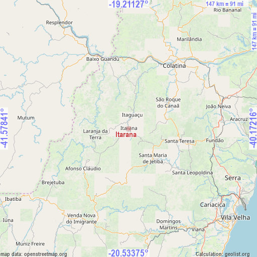
Itarana GPS coordinates[2]
19° 52' 26.004" South, 40° 52' 31.008" West
| Map corner | latitude | longitude |
|---|---|---|
| Upper-left | -19.21127°, | -41.57841° |
| Center: | -19.87389°, | -40.87528° |
| Lower-right: | -20.53375°, | -40.17216° |
| Map W x H: | 147×147 km | = 91.3×91.3mi |
| max Lat: | 2.81972° ⇑56.3% North |
| Itarana: | -19.87389° |
| min Lat: | ⇓43.7% South -33.69111° |
| min Long | Itarana | max Long |
| -72.89583° | -40.87528° | -32.41083° |
| W 70.6%⇐ | ⇒29.4% E |
Elevation
Elevation of Itarana is 193 m = 633 ft, and this is 187.9 m = 616 ft below average elevation for this country.
| Max E: |
1603 m = 5259 ft | 61.9% |
| Avg. | 380.9 m = 1250 ft | |
| Itarana | 193 m = 633 ft | |
Min E: |
0 m = 0 ft | 38.1% |
See also: Brazil elevation on elevation.city.
Geographical zone
Itarana is located in South Torrid zone (between Equator and Tropic of Capricorn). Distance of this Southern Tropic circle is 396.1 km =246.1 mi to South.| Distance of | km | miles | from Itarana |
|---|---|---|---|
| Equator | 2209.8 | 1373.1 | to North |
| Tropic Capricorn | 396.1 | 246.1 | to South |
| Antarctic Circle | 5191.4 | 3225.8 | to South |
| South Pole | 7797.3 | 4845 | to South |


Nearby cities:
15 places around Itarana: (largest is in red/bold)
• Afonso Cláudio
34.2 km =21.3 mi,  229°
229°
• Aimorés
46.4 km =28.8 mi,  334°
334°
• Baixo Guandu
42.1 km =26.2 mi,  339°
339°
• Colatina
45.2 km =28.1 mi,  34°
34°
• Domingos Martins
58.9 km =36.6 mi,  157°
157°
• Fundão
49.6 km =30.8 mi,  97°
97°
• Ibiraçu
53.1 km =33 mi,  84°
84°
• Itaguaçu
8.3 km =5.2 mi,  14°
14°
• Jetibá
26 km =16.2 mi,  128°
128°
• João Neiva
52.8 km =32.8 mi, 75°
• Laranja da Terra
19.2 km =11.9 mi,  261°
261°
• Mutum
59.5 km =37 mi,  277°
277°
• Santa Leopoldina
44 km =27.3 mi,  124°
124°
• Santa Maria de Jetibá
21.9 km =13.6 mi,  141°
141°
• Santa Teresa
29.6 km =18.4 mi, 103°
Sources, notices
• [Note1] Compared only with cities in Brazil existing in our database
• [Src1] Map data: © OpenStreetMap contributors (CC-BY-SA)
• [Src2] Other city data from geonames.org with taken over terms of usage.
• [Src3] Geographical zone / Annual Mean Temperature by Robert A. Rohde @ Wikipedia
